

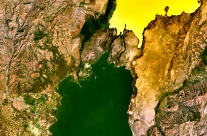
A group of cinder cones at Tosa Sucha lies near the northern shore of Lake Chamo, the greenish lake at the bottom-center portion of this NASA Landsat image (with north to the top). The cones occupy a faulted area between Lake Chamo and the southern end of yellowish Lake Abaya. Some cones form islands in Lake Chamo. The unvegetated olivine basaltic lava flows have been estimated to perhaps have been active as recently as historical time. NASA Landsat7 image (worldwind.arc.nasa.gov)
INSIVUMEH reported that on 10 September seismic stations monitoring Santa María's Santiaguito lava dome complex detected a lahar below the S flank in the Nima I River. The lahar, about 18 m wide and up to 2 m deep, carried blocks and smelled of sulfur.
The Darwin VAAC reported that on 16 September a low-level ash plume from Bagana rose to an altitude of 2.4 km (8,000 ft) a.s.l.
The Smithsonian's Global Volcanism Program seeks better understanding of all volcanoes through documenting their eruptions — small as well as large — during the past 10,000 years.