
|
||
|
|
||
| View other datasets |
|
|
| ||
 |
|||
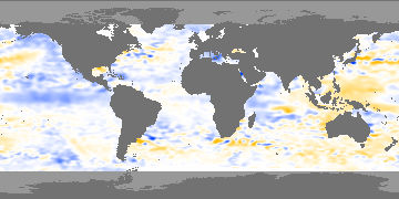
| Coverage of this dataset spans October 1992 to December 1999. | |||
The animation features of the Earth Observatory are currently unavailable. We apologize for the inconvenience. To view the full temporal span of this dataset, please view the Sea Surface Height monthly holdings. | |||
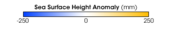 Product description: Sea surface height measurements provide insights into ocean circulation, climate cycles such as El Niño, sea-level rise, and ocean tides. These data are presented as anomalies, the difference between the measured height at a given time and the average height of the ocean surface at that location. Sea-levels lower than normal are colored blue, while higher than normal are yellow. Levels at or near average sea level are white. These measurements were made by the radar altimeter aboard the TOPEX/Poseidon satellite. Ocean currents transport water around the globe, lift cold water from the sea floor to the surface, and pull warm water from the equator towards the poles. Sea surface height data show currents because warm water is less dense than cold water, so the warm water tends to be higher than cold water. Scientists use the data to study the location of currents, their variabilty from season to season and over a period of years, and the transport of heat from the equator to the poles—a driving force of the global climate. Because the height of the ocean surface is influenced by the entire volume of water to the ocean bottom, sea surface height data also reveals the state of subsurface water. This is particularly helpful in monitoring flucuations related to El/Niño and La Niña, as well as longer-term cycles such as the Pacific Decadal Oscillation (read El Niño’s Extended Family for more information about these patterns). Long-term measurements of sea-surface height also provide data on sea level rise due to global warming, which complement surface sea level gauges. These data also reveal the energy related to tidal motions in the oceans. These data are archived at the JPL Physical Oceanography Distributed Active Archive Center.
|
|
Subscribe to the Earth Observatory About the Earth Observatory Contact Us Privacy Policy and Important Notices Responsible NASA Official: Lorraine A. Remer Webmaster: Goran Halusa We're a part of the Science Mission Directorate |