
|
||
|
|
||
| View other datasets |
|
|
|||
 |
|||
| | |||
The animation features of the Earth Observatory are currently unavailable. We apologize for the inconvenience. To view the full temporal span of this dataset, please view the Landcover Classification monthly holdings. | |||
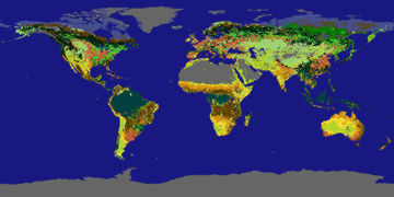
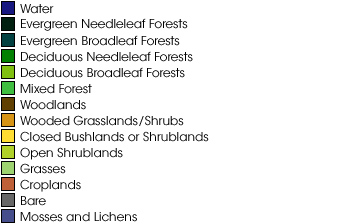 Product description: Landcover classification is a description of the type of vegetation growing in an area. Different types of plants (e.g., grasses versus pine trees) reflect uniquely, giving a 'spectral signature'. Scientists use satellites to detect the spectral signature of vegetation and produce landcover classification maps from the data. Landcover classification data has applications in urban planning, natural resources management, wildlife biology, and forestry. (Data produced by the University of Maryland)
|
|
Subscribe to the Earth Observatory About the Earth Observatory Contact Us Privacy Policy and Important Notices Responsible NASA Official: Lorraine A. Remer Webmaster: Goran Halusa We're a part of the Science Mission Directorate |