|
||
Glacial Collapse Threatens Huaraz, Peru
| ||||
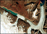
A chunk of glacier was threatening to fall into an Andean lake and cause major flooding in a Peruvian city of 60,000. A fissure has appeared in the glacier that feeds the Lake Palcacocha near the city of Huaraz, 270 km north of Lima. If the piece breaks off, ensuing floods would take 15 minutes to reach the city. In 1941, the lake overflowed and caused massive destruction, killing 7,000 people. The city can be seen in the left-center part of the image. Lake Palcacocha is in the upper right corner of the image at the head of a valley, below the snow and glacier cap. The Advanced Spaceborne Thermal Emission and Reflection Radiometer (ASTER) instrument, aboard NASA’s Terra satellite, is being tasked to obtain current images of the glacier to help monitor the situation. Size of full-resolution image: 31.8 x 31.8 km (19.7 x 19.7 miles)
Image courtesy NASA/GSFC/MITI/ERSDAC/JAROS, and U.S./Japan ASTER Science Team Recommend this Image to a Friend Back to: Newsroom
Also see |
View Images Index
| |||
|
Subscribe to the Earth Observatory About the Earth Observatory Contact Us Privacy Policy and Important Notices Responsible NASA Official: Lorraine A. Remer Webmaster: Goran Halusa We're a part of the Science Mission Directorate |
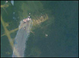
 Click here to view full image
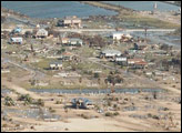