
|
||
|
|
||
| View other datasets |
|
|
| ||
 |
|||
| Coverage of this dataset spans January 1978 to December 1996. | |||
The animation features of the Earth Observatory are currently unavailable. We apologize for the inconvenience. To view the full temporal span of this dataset, please view the Snow Cover and Ice Depth monthly holdings. | |||
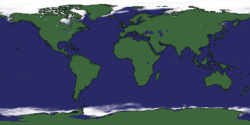
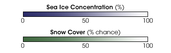 Product description: Snow and ice cover the Earth's polar regions all year round. (In this data set, snow cover data are available only for the Northern Hemisphere, which is why Antarctica appears green). At mid-latitudes, the extent of snow and ice cover varies as the seasons change. In the fall and winter months (and occasionally into spring) snowstorms lay white carpets of snow across our world's landscapes as sea surface temperatures grow cold enough to freeze lake and sea water. It is important for scientists to measure the global extent of snow and ice because this helps them to determine how much radiant energy enters and leaves the Earth's system. Snow and ice are highly reflective and therefore raise our planet's albedo (sunlight reflected back to space). On a regional scale, scientists track snow and ice extent because many communities rely upon snow melt as a primary source of freshwater; alternatively, too much snow melt can lead to floods during the spring thaw. In the false-color image(s) above, white shows where the surface is covered by snow or ice, green indicates bare land surface, and blue indicates bare water surface. (Please note that there is no snow cover data for 1996, and there are intermittent gaps in the sea ice data.) Each image represents a global one-month composite of snow and ice cover, spanning from 1978-96. These data were acquired by the Nimbus-7 Scanning Multichannel Microwave Radiometer (SMMR) and the DMSP Special Sensor Microwave/Imager (SSM/I). (Images by Jennifer Bohlander, NSIDC; Data courtesy National Snow and Ice Data Center)
|
|
Subscribe to the Earth Observatory About the Earth Observatory Contact Us Privacy Policy and Important Notices Responsible NASA Official: Lorraine A. Remer Webmaster: Goran Halusa We're a part of the Science Mission Directorate |