
Program Summary
 The geomagnetic
field is generated by electric currents located in many different
parts of the Earth. In the outer core the main part of the geomagnetic
field is sustained by a naturally occurring dynamo. In the mantle currents
can be induced by time-dependent variations in the ambient magnetic field.
In the crust the field has both induced and permanent components. And,
in the ionosphere and magnetosphere electric currents are sustained through
a complicated interaction with the Sun, the heliomagnetic field, and the
solar wind of charged particles. The many different, and sometimes remote,
sources of the Earth's magnetic field each contribute to the total field
at any one particular location, with the very different physical processes
in each domain giving rise to a wide variety of time-dependent geomagnetic
variations. Therefore, through the analysis of the time series of the
magnetic field from different geographic locations, the different source
regions, be they below or above the Earth's surface, can be studied for
the purposes of scientific knowledge and understanding.
The monitoring and analysis of the geomagnetic field is also important
for practical applications, some of which have been made for centuries.
The magnetic field can
The geomagnetic
field is generated by electric currents located in many different
parts of the Earth. In the outer core the main part of the geomagnetic
field is sustained by a naturally occurring dynamo. In the mantle currents
can be induced by time-dependent variations in the ambient magnetic field.
In the crust the field has both induced and permanent components. And,
in the ionosphere and magnetosphere electric currents are sustained through
a complicated interaction with the Sun, the heliomagnetic field, and the
solar wind of charged particles. The many different, and sometimes remote,
sources of the Earth's magnetic field each contribute to the total field
at any one particular location, with the very different physical processes
in each domain giving rise to a wide variety of time-dependent geomagnetic
variations. Therefore, through the analysis of the time series of the
magnetic field from different geographic locations, the different source
regions, be they below or above the Earth's surface, can be studied for
the purposes of scientific knowledge and understanding.
The monitoring and analysis of the geomagnetic field is also important
for practical applications, some of which have been made for centuries.
The magnetic field can
 be used for orientation, navigation, and mineral and oil exploration.
Of more recent interest, the infrastructure and the activities of our
modern, technologically-based society can be adversely affected by rapid
magnetic-field variations driven by the dynamic processes in the near-Earth
space environment. This is particularly true during so-called ‘magnetic
storms’, when radio communication can be difficult or impossible,
global-positioning systems (GPS) can be degraded, satellite electronics
can be damaged, satellite drag can be enhanced, astronaut and high-altitude
pilots can be subjected to increased levels of radiation, pipe-line corrosion
can be enhanced, and electric-power grids can experience voltage surges
which cause blackouts. The most beautiful manifestations of geomagnetic
activity are aurorae, seen prominently at high latitudes near the geomagnetic
poles. Given the plurality of geomagnetic phenomena, it is not surprising
that the communities concerned with magnetic data are numerous and diverse.
be used for orientation, navigation, and mineral and oil exploration.
Of more recent interest, the infrastructure and the activities of our
modern, technologically-based society can be adversely affected by rapid
magnetic-field variations driven by the dynamic processes in the near-Earth
space environment. This is particularly true during so-called ‘magnetic
storms’, when radio communication can be difficult or impossible,
global-positioning systems (GPS) can be degraded, satellite electronics
can be damaged, satellite drag can be enhanced, astronaut and high-altitude
pilots can be subjected to increased levels of radiation, pipe-line corrosion
can be enhanced, and electric-power grids can experience voltage surges
which cause blackouts. The most beautiful manifestations of geomagnetic
activity are aurorae, seen prominently at high latitudes near the geomagnetic
poles. Given the plurality of geomagnetic phenomena, it is not surprising
that the communities concerned with magnetic data are numerous and diverse.
 Because
the Earth’s magnetic field is complicated in space and time, because
it has such a variety of causes and affects, and because it is of both
scientific interest and practical importance, the USGS Geomagnetism Program
has, for over a century, monitored the field through a network of magnetic
observatories and conducted scientific
analysis on those data.
The Program traces its origins to the Reorganization Act of 1843 in which
Congress authorized the creation of a coastal survey agency, as part of
the Treasury Department, that was responsible for, among other things,
geomagnetic surveys. The 19th century saw the establishment of relatively
short-lived magnetic stations, as well as the production of declination
maps for the United States and Territories. With the purchase of Alaska,
coastal surveys became an increasingly higher priority, and in 1889 the
Coast and Geodetic Survey, with a Division of Terrestrial Magnetism, was
established. The first essentially permanent geomagnetic observatories
were established under the Division’s leadership of
Because
the Earth’s magnetic field is complicated in space and time, because
it has such a variety of causes and affects, and because it is of both
scientific interest and practical importance, the USGS Geomagnetism Program
has, for over a century, monitored the field through a network of magnetic
observatories and conducted scientific
analysis on those data.
The Program traces its origins to the Reorganization Act of 1843 in which
Congress authorized the creation of a coastal survey agency, as part of
the Treasury Department, that was responsible for, among other things,
geomagnetic surveys. The 19th century saw the establishment of relatively
short-lived magnetic stations, as well as the production of declination
maps for the United States and Territories. With the purchase of Alaska,
coastal surveys became an increasingly higher priority, and in 1889 the
Coast and Geodetic Survey, with a Division of Terrestrial Magnetism, was
established. The first essentially permanent geomagnetic observatories
were established under the Division’s leadership of
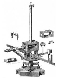 Drs
Louis A. Bauer and John
A. Fleming: the Cheltenham Maryland observatory was established in
1900, subsequently moved to the Fredericksburg site in 1956; the Sitka
Alaska observatory was established in 1901 and that of Honolulu Hawaii
in 1902. Soon after these observatories were made operational, it was
found that the Sitka and Honolulu magnetometers were also sensitive to
local earthquakes, and so seismometers were installed on those sites.
In part, because of this co-location of instruments, the magnetic and
seismological Programs in the Coast and Geodetic Survey were united in
1925 under the Division of Geomagnetism and Seismology. Over the years,
the Geomagnetism Program has evolved in response to the needs of the country
and in response to changes in the nation’s various federal agencies.
In 1903 the Coast and Geodetic Survey was transferred to the newly organized
Department of Commerce, and in 1970 the Survey was itself reorganized
into the National Oceanic and Atmospheric Administration. In 1973 the
US Geological Survey of the Department
of the Interior assumed responsibility for the nation’s Geomagnetism
and Seismology Programs.
Drs
Louis A. Bauer and John
A. Fleming: the Cheltenham Maryland observatory was established in
1900, subsequently moved to the Fredericksburg site in 1956; the Sitka
Alaska observatory was established in 1901 and that of Honolulu Hawaii
in 1902. Soon after these observatories were made operational, it was
found that the Sitka and Honolulu magnetometers were also sensitive to
local earthquakes, and so seismometers were installed on those sites.
In part, because of this co-location of instruments, the magnetic and
seismological Programs in the Coast and Geodetic Survey were united in
1925 under the Division of Geomagnetism and Seismology. Over the years,
the Geomagnetism Program has evolved in response to the needs of the country
and in response to changes in the nation’s various federal agencies.
In 1903 the Coast and Geodetic Survey was transferred to the newly organized
Department of Commerce, and in 1970 the Survey was itself reorganized
into the National Oceanic and Atmospheric Administration. In 1973 the
US Geological Survey of the Department
of the Interior assumed responsibility for the nation’s Geomagnetism
and Seismology Programs.
Today,
Geomagnetism is one of four Programs, in addition to the National
Earthquake Hazards, the Global
Seismic Network, and the Landslides
Programs, represented by the USGS
Central Region Geohazards Team in Golden,
Colorado. Unlike the Earthquake Hazards Program, which supports many
different projects based primarily in Menlo Park and in Golden, the National
Geomagnetism Program is a self-contained entity within the Bureau and
the Team. A major part of the Program is concerned with operating and
maintaining magnetic observatories located in the
United States and its Territories.
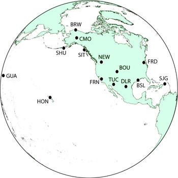 The observatories, which support modern digital acquisition systems, are
designed to produce long time series of stable magnetometer
data having high accuracy and resolution. The Program collects, transports,
and can disseminate these data in near-real time, and it also has significant
data-processing and management capacities. By necessity, the network,
and everything associated with handling the data, is technologically elaborate;
it consists of many finely tuned components, each of which need to be
operated in careful synchronization. In some respects, the operational
and developmental activities of the Geomagnetism Program have an abstract
similarity to those of the Geohazard Team’s seismology programs,
which are also concerned with the treatment of time series of data collected
from remote sites. As a result, because of similar operational philosophies,
opportunities for sharing infrastructure and software, and common interests
in time-series and statistical data-analysis methodologies, the Geomagnetism
Program benefits from being situated within the Golden Geohazards Team.
Of course, from a scientific standpoint, the Geomagnetism Program retains
its own specialized niche within the Geohazards Team and the USGS. The
Program has an important and influential base of customers
who rely on its data and data-based products. The Program has numerous
cooperative partnerships,
and Program staff work with governmental,
academic, and private agencies, both within the United States and worldwide.
Finally, the USGS Geomagnetism Program is an integral part of the Federal
Government's National
Space Weather Program as outlined in its Strategic
Plan
The observatories, which support modern digital acquisition systems, are
designed to produce long time series of stable magnetometer
data having high accuracy and resolution. The Program collects, transports,
and can disseminate these data in near-real time, and it also has significant
data-processing and management capacities. By necessity, the network,
and everything associated with handling the data, is technologically elaborate;
it consists of many finely tuned components, each of which need to be
operated in careful synchronization. In some respects, the operational
and developmental activities of the Geomagnetism Program have an abstract
similarity to those of the Geohazard Team’s seismology programs,
which are also concerned with the treatment of time series of data collected
from remote sites. As a result, because of similar operational philosophies,
opportunities for sharing infrastructure and software, and common interests
in time-series and statistical data-analysis methodologies, the Geomagnetism
Program benefits from being situated within the Golden Geohazards Team.
Of course, from a scientific standpoint, the Geomagnetism Program retains
its own specialized niche within the Geohazards Team and the USGS. The
Program has an important and influential base of customers
who rely on its data and data-based products. The Program has numerous
cooperative partnerships,
and Program staff work with governmental,
academic, and private agencies, both within the United States and worldwide.
Finally, the USGS Geomagnetism Program is an integral part of the Federal
Government's National
Space Weather Program as outlined in its Strategic
Plan
