
|
||
|
|
||
|
|||
|
In April 2008, atmospheric scientist Kevin Gurney and several colleagues from Purdue, Colorado State University, and Lawrence Berkeley National Laboratory published the first detailed inventory of carbon dioxide emissions from the burning of fossil fuels across the United States. Known as the Vulcan Project, for the Roman god of fire, the inventory catalogues how much carbon dioxide different human activities produce on an hourly, daily, and monthly basis—from vehicles to industrial activity to electricity used by homes or businesses. |
|||

|
Prior to the Vulcan Project, most estimates of fossil fuel emissions were based on population density as a stand-in for actual measurements. “We had annual estimates at the national level, which you can get from basic UN [United Nations] statistics derived from sales of coal, oil, and natural gas around the world. But people would distribute them within a country based on population density,” said Gurney. |
The Vulcan Project maps American carbon dioxide emissions. The map shows annual emissions in 2002 (kilotons of carbon) from urban centers (larger red patches), widely scattered point sources like remote power stations or smelters (small red dots), and highways. (Map by Jesse Allen, based on data from the Vulcan Project.) |
||

In contrast, Gurney and his team tallied up emissions from specific human activities where they actually occur and summarized them by city, county, and state. Sponsored by NASA and the Department of Energy as part of the North American Carbon Program, the inventory will help advance carbon cycle science and could help the United States as it develops strategies for reducing the carbon dioxide emissions that are driving global warming. |
Kevin Gurney of Purdue University led the small team of scientists and computer programmers on the Vulcan Project. Itemizing the human-generated part of the U.S. carbon budget was a departure from his previous work, which focused on the role of vegetation as a natural carbon sink. (Photograph ©2007 Kevin Gurney.) |
||
|
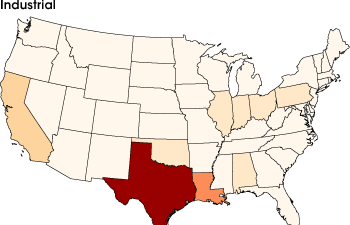
The Vulcan inventory summarizes emissions from different processes. With a concentration of oil refineries along the Gulf Coast, Texas leads the nation in industrial emissions of carbon dioxide. Texas’ 5.7 gigatons of carbon per year is 50 percent more than neighboring Louisiana’s emissions, and 150 percent more than third-place California’s. |
||
|
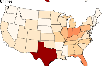
Texas’ emissions from utilities are higher than California’s, even though California has a larger population. This reversal is partly because California imports electricity from surrounding states. Coal-fired power plants in the Ohio Valley export electricity to the Northeast, making utility emissions in less populated states, including West Virginia and Kentucky, higher than more populated states, like New Jersey and New York. |
||
|
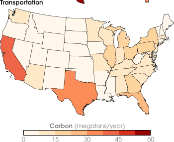
California, famous for its car culture, has the highest carbon dioxide emissions for the transportation sector. Wide-open Texas also has relatively high emissions. Nationally, transportation emissions are higher in the East than the West. (Maps by Jesse Allen, based on data from the Vulcan Project.) |
||
The Need for a Better InventoryThe project evolved as a sideline from Gurney’s research on the natural carbon cycle and the mystery of the “missing carbon sink.” The mystery is that atmospheric carbon dioxide levels in the Northern Hemisphere are lower than scientists would expect given the amount of fossil fuels we burn. Somewhere, there is a missing carbon sink, a place or places that are taking in more carbon dioxide than scientists expected. A few years ago, NASA began firming up its plans to launch the Orbiting Carbon Observatory (“OCO” for short) satellite in late 2008 or 2009. OCO will provide the smaller scale, more frequent measurements of carbon dioxide in the atmosphere that scientists need to pinpoint the Northern Hemisphere’s missing carbon sink. It was at this point that Gurney got sidetracked by the fossil fuel inventory. “When NASA began talking about its plans for OCO,” he says, “we thought, ‘OK, we are going to have the observations of CO2 in the atmosphere at smaller scale, but now we have a big looming problem, which is we just don’t know fossil fuel emissions well enough at that scale.” In other words, scientists would have more detail on where carbon dioxide winds up, but still not enough detail about where it came from. A demand for more detail on emissions also began to emerge from the community of people thinking about energy policy and emission regulation. “A decade ago,” says Gurney, “the policy community was thinking in very broad terms about emissions mitigation at a national level.” But in recent years, policymakers on the state and local level have become increasingly interested in reducing their carbon footprint through locally tailored strategies. These science and policy needs motivated Gurney to propose Vulcan. Making the Data You Have into the Data You NeedTo create the inventory, Gurney and his colleagues relied on existing data at numerous state and federal agencies, including the Environmental Protection Agency, the Federal Highway Administration, and the Census Bureau. Nobody specifically collected data on carbon dioxide emissions, but they each collected data that could be fed into models that would allow Gurney to estimate them. The EPA had data on how much carbon monoxide industries, power plants, or urban areas generate; what kinds of devices produced it, and the kind and amount of fuel they used. Knowing all these things, says Gurney, “I can figure out how much CO2 was emitted quite easily with simple combustion models.” In addition to pollution records, they used county records of everything from the square footage of commercial and residential buildings, to the miles of roads, to how many and what kinds of cars were registered. They gathered these records up, figured out how to tease carbon dioxide emissions from them, and mapped them on a common grid. |
|||
|
Subscribe to the Earth Observatory About the Earth Observatory Contact Us Privacy Policy and Important Notices Responsible NASA Official: Lorraine A. Remer Webmaster: Goran Halusa We're a part of the Science Mission Directorate |
|
|