|
ARD GIS Tools
GIS Tools represents a collection of scripts and extensions used by the ARD GIS Team and our Partners. These tools were either developed by ARD or collected by ARD for use in Watershed Database and Mapping Projects.
These tools aid in analysis and mapping spatial data by simplifying or automating tasks and providing functionality to accomplish complex tasks. These GIS scripts and extensions include:
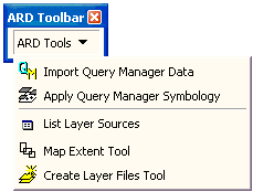
- Import, projection and symbolizing ARD Query Manager Data
- Facilitating the use of OR&R Environmental Sensitivity Index (ESI) data
- Calculating Area/Length/Perimeter
- Labeling multiple co-located points (Cores)
- Image catalog (boundaries) creation
- Adding X/Y coordinates to a table
- Import hazardous material potential footprint ouput from OR&R ALOHA software
- Import NOAA raster charts and ENC's
- Creation of metadata files
Most of these GIS Tools are written for either ArcView 3.x or ArcGIS 9.x. Some tools, such as Query Manager Import Utility are written for use in both ArcView 3.x and ArcGIS 9.x. ArcGIS 9.x tools will be the focus of ongoing development for NOAA ARD.
Downloads
|
- ARD GIS Toolbar for ArcView 9.x
Download the Toolbar, which includes Query Manager Import, for ArcView 9.x.
(This ActiveX dll file will download as a compressed file.)
(Software format: Zip, size: 90.7 K)
|
- CPRD GIS Tool Box Download the Toolbox extension for ArcView 3.x.
(This ArcView 3.x Extension will download as a compressed file.)
(Software format: Zip, size: 55.1 K)
|
|
|
|