|
Downloading ESI Maps and GIS Data
Environmental Sensitivity Index (ESI) maps and data can be downloaded for free from NOAA sites in a variety of formats. (Alternately, you can purchase an ESI CD/DVD with all of the formats that are available for that atlas of ESI maps.)
Geodatabase Data and ESI Viewers
From this site, you can download two types of ESI products:
- Geodatabase Data. Download the latest version of ESI GIS data in the geodatabase format (for use in ESRI's ArcMap product).
- ESI Viewers. Download the latest version of this freeware mapping and database engine, which allows you to view, print, and run simple queries on the ESI data. Both Macintosh and Windows formats are available.
PDF Maps and GIS Data
From the Data Explorer site (NOAA's National Ocean Service spatial data collection), you can download electronic versions of the ESI atlases that are available on CD/DVD. These downloads include the entire contents of the ESI CD/DVD: ESI maps in PDF format, ESI data in GIS formats, and useful ESI resources. Review the ESI availability page to find out what formats are available for your area.
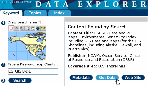
To download resources from the Data Explorer site:
- Click on the Data Explorer link at the bottom of this page to go to that site.
- Click on the Get Data button. A map appears with all of the ESI areas marked.
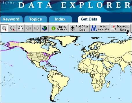
Click on the Download Data button. A list of available ESI atlases will appear; these are the atlases that are also available from OR&R on CD/DVDs.
Choose the ESI atlases that you want to download.
Click on the Continue button.
Enter your e-mail address.
Click on the Download button, and then on Close. An e-mail will be sent to you with a link to a download site for the files you selected.
When the e-mail arrives, click on the ESI CD link (usually the last link in the e-mail). Note: If you selected multiple atlases, there will be separate links for each ESI CD.
Select the location where you want to save the ESI atlas. A zip file that contains all of the information on the ESI CD will begin downloading. The ESI files can be very large, so the download may take a while.
Once your download is complete, unzip the files. Now you have access to all of the information on the ESI CD for that atlas.
Data Explorer Web Site
|
- Data Explorer Download OR&R's ESI maps and GIS data from the National Ocean Service spatial data collection. [leaves OR&R site]
|
|