|
Field Tools Team: Equipping On-scene Responders and Improving Situational Awareness
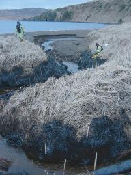
The Field Tools Team works to advance on-scene response capabilities through the development of tools for data collection, synthesis, management, and sharing. The FTT integrates handheld computing systems, the Global Positioning System (GPS), and networking, digital camera, and database technologies in order to expedite the transfer of field observations into decision-making products such as GIS maps and reports which increase the efficiency of response operations and minimize resource damages. The integrated solutions provided by the FTT not only ensure that information flows in a timely manner, but that information is of high quality. Improving Shoreline Clean-up and Assessment Technique (SCAT) operations is a principle focus of the FTT. Where possible, the FTT also seeks to extend their expertise and tools to serve problems such as marine debris cleanup, a problem which, similar to spill clean-up, requires that accurate descriptive and geospatial information be synthesized into products that serve operations and inform management decisions. In developing integrated solutions, the FTT seeks to establish data collection and management protocols which scale to incidents of varied magnitudes and enable inter-agency response. The FTT recognizes the need for the response community to develop custom tools and products and strives to ensure that these custom solutions can be mobilized and that the information they generate are made accessible to decision-makers, scientists, and the public.
Current Projects
- The Environmental Response Data Collection Standards Workshop, funded by the Marine Debris Program and the University of New Hampshire Coastal Response Research Center (CRRC), is being planned for September 25-27 in New Hampshire. The workshop will bring together representatives from local, state and federal governments, industry, and academia in order to establish standards for response and marine debris data collection.
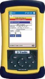
- Electronic SCAT (eSCAT) is an application for SCAT team members to rapidly record field observations using a handheld PDA with integrated GPS. The application is highly integrated with the SCAT database (SCATdb) so that observation choices are standardized, maximizing usability and ensuring that data moves seamlessly into centralized information management. The application is in testing, written in the open source Python language, and targeted for the Windows PocketPC operating system.
- SCAT database (SCATdb) is a database capable of managing SCAT data collected through eSCAT or through traditional SCAT forms. SCATdb enforces data quality and supports robust GIS products and reporting.
- Command Post Network – improves data storage, accessibility, and continuity
- Photologger aids responders in managing their incident photographs. When photos are acquired in combination with a GPS device, photos can quickly be geo-positioned and overlaid on GIS maps. Through the application, a photographer can easily tag, assign metadata to, archive, and distribute their photos. Photologger is a Microsoft Access database. In the future, this system will be integrated with the ORR’s Response Link incident information portal.
Past Projects
- SCAT Workshops
- Safe Seas 2006
Future Projects
- Situational awareness aids – tides, weather, job aids, radio channels, contact info, etc.
- Electronic Overflight Observation Software
- Adapting handheld software applications beyond SCAT data collection to other field surveying missions that have geospatial and descriptive aspects similar to SCAT. Examples include: marine debris, resource monitoring, and Natural Resource Damage Assessment (NRDA).
Downloads
|
- Field Tools Poster A high-level overview of FTT products in the context of SCAT and marine debris cleanup operations.
(Document format: PDF, size: 2.2 M)
|
|