Emergency Response
Emergency Response
Emergency Response
Pollutants in the Environment
Serving Communities
Natural Resource Restoration

Information for:
Emergency Responders
Students and Teachers
Interested Public
Research Institutions
Other Agencies

Current News
Special Note
FAQs

Catalogs of:
Publications
Software & Data Sets
Web Portals
Links
Downloads
Image Galleries
Abandoned Vessels
Drift Card Studies

About OR&R
Contact Us
Advanced Search
Site Index
Privacy Policy
Document Accessibility

Emergency ResponseHome | Image Galleries | Emergency Response

Shoreline Types (by ESI Rank)

Photo examples of 15 major shoreline types, listed in order of their Environmental Sensitivity Index (ESI) rank, from least sensitive to damage from spilled oil (lowest numbers) to most sensitive (highest numbers). [Part of the Shoreline Assessment Job Aid.]

Click on an image below to see the full image.

Large rocky outcrops in water

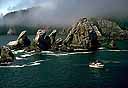
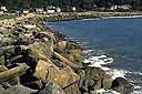
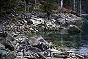
1. Exposed Rocky Shores
(08.19.04, unknown) Exposed rocky shores (also includes exposed seawalls)

Grooved shoreline with rising cliffs

2. Exposed Rocky Platforms
(08.19.04, unknown) Exposed rocky platforms (also includes clay scarps)

Smooth beach

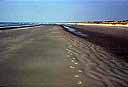
3. Fine-grained Sand Beaches
(08.19.04, unknown) Fine-grained sand beaches (also includes scarps in sand)

Sandy beach with people walking in the distance

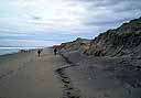
4. Coarse-grained Sand Beaches
(08.19.04, unknown) Coarse-grained sand beaches

Sand and gravel beach with small plane on the ground

5. Mixed Sand and Gravel Beaches
(08.19.04, unknown) Mixed sand and gravel beaches
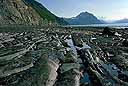
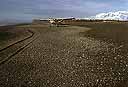
Rocky beach with mountains in background

6a. Gravel Beaches
(08.19.04, unknown) Gravel beaches

Large boulders line shore

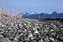
6b. Riprap Structures
(08.19.04, unknown) Riprap structures

helicopter on rippled half-flooded tidal flats

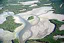
7. Exposed Tidal Flats
(08.19.04, unknown) Exposed tidal flats

Mixed sized of rocks along shore at forest edge

8a. Sheltered Rocky Shores
(08.19.04, unknown) Sheltered rocky shores

Pier in small harbor

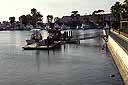
8b. Sheltered Artificial Structures
(08.19.04, unknown) Sheltered artificial structures

aerial view of green tidal flats

9. Sheltered Tidal Flats
(08.19.04, unknown) Sheltered tidal flats

Green grass rises from the water at the edge of this saltwater marsh

10a. Salt to Brackish Marshes
(08.19.04, unknown) Salt to brackish marshes

Closeup of grass and reeds at water

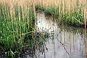
10b. Freshwater Marshes
(08.19.04, unknown) Freshwater marshes
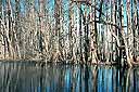
Row of trees rising from water

10c. Swamps
(08.19.04, unknown) Swamps
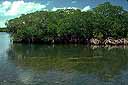
Cluster of Mangrove trees along edge of water

10d. Mangroves
(08.19.04, unknown) Mangroves

Related Pages on Our Site
  • ESI Toolkit Tools and resources for Environmental Sensitivity Index maps.
  • Shoreline Assessment Job Aid A supplement to the Shoreline Assessment Manual, containing visual examples of many of the terms you would use during shoreline assessments after an oil spill.
NOAA logo