|
Charter Vessel Scuttled on Pearl and Hermes Atoll in NW Hawaiian Islands
 |
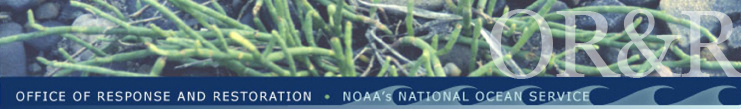
USCG cutter Walnut transfers fuel off the grounded vessel Casitas,
July 10, 2005. Photo: USCG
|
Crew rescued, fuel removed, vessel refloated and successfully scuttled
On July 2, 2005, the M/V Casitas, owned and operated by F/V Northwind Inc., a Seattle-based company, ran aground on Pearl and Hermes Atoll in the Northwestern Hawaiian Islands (NWHI). NOAA had chartered the 145-foot Casitas to assist in marine debris removal in the remote island chain. The NOAA ship Oscar Elton Sette picked up all 23 people on board, including the crew and 16 divers from the NOAA/University of Hawaii Joint Institute for Marine and Atmospheric Research, and transported them safely to Midway Atoll. On Wednesday, July 5, the U.S. Coast Guard (USCG) returned all of them to Oahu, Hawaii via C-130 Hercules aircraft.
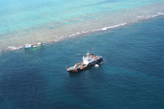
At the time of the grounding, the Casitas had on board approximately 30,000 gallons of diesel fuel; 3,000 gallons of gasoline; 200 gallons of lube oil; and 14 metric tons of marine debris. On July 8, the USCG Cutter Walnut arrived on-scene and successfully removed nearly all of the diesel fuel from the vessel. The first week of August, specialized salvage vessels arrived and were able to transfer approximately 1,850 gallons of gasoline from the Casitas to the 240-foot barge serving as the operations base for the extraction. Early morning on August 4, ballast water was pumped from the Casitas to refloat the vessel. Additional holes in the hull were patched and pumps were kept operating to keep the Casitas afloat until it reached an approved disposal site that afternoon. The vessel was entombed northwest of the atoll in approximately 7,200 feet of water. Because of safety concerns, the marine debris was sealed in the vessel's holds.
NOAA's Role
NOAA OR&R (Office of Response and Restoration) provides both scientific and technical support to the USCG during an oil spill, and acts as a natural resource trustee to protect and restore those resources impacted by the spill. NOAA's support includes providing predictions of where fuel oil would go if it were spilled, assessments of natural resources at risk, and daily weather reports. The USCG, NOAA, the state of Hawaii, U.S. Fish and Wildlife Service, and the responsible party all worked together to develop and execute plans for the removal of the Casitas from the reef while minimizing physical harm to the reef. Now that the vessel is removed, NOAA scientists will participate in field assessment studies to determine the extent of impacts and potential for restoration activities.
 |
|
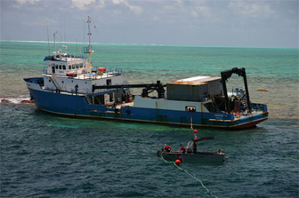
Rigging the hoses for fuel transfer, July 9, 2005. Photo: USCG
|
The NWHI Coral Reefs
Pearl and Hermes Atoll is 86 nautical miles (nm) southeast of Midway Atoll and 1,200 nm from Honolulu, Hawaii. Pearl and Hermes is comprised of several small islands, totaling only 80 acres, surrounded by over 450 square miles of coral reefs. The atoll and reef system are part of the state of Hawaii. The U.S. Fish and Wildlife Service manages the atoll as part of the Hawaiian Islands National Wildlife Refuge. NOAA manages the recently designated Northwestern Hawaiian Islands Coral Reef Ecosystem Reserve (NWHICRER), which extends from the 3 nm territorial seas boundary out to 50 nm. Except for visiting scientists, the islands are uninhabited. For other maps of the atoll, please visit the Center for Coastal Monitoring and Assessment's Northwest Hawaiian Island Maps.
The NWHI coral reefs are the foundation of an ecosystem that hosts more than 7,000 species, including marine mammals, fishes, sea turtles, birds, and invertebrates. Many are rare, threatened, or endangered. The living coral reef colonies of the NWHI are a spectacular underwater landscape covering thousands of square miles and comprising the majority of coral reefs in the United States. NOAA has initiated the process to designate the NWHICRER as our country's 14th (and largest) national marine sanctuary. These remote reefs are some of the healthiest and most undisturbed coral reefs on the planet.
NOAA's Marine Debris Program
Over the past several years, the NWHI have been the focus of a multi-agency marine debris removal effort. Nets and other persistent marine debris have become stranded in the extensive reef system, damaging corals and entangling wildlife. Since 2000, NOAA and partners have removed over 400 metric tons of marine debris from the NWHI. By the end of 2005, the majority of existing accumulations of debris will be removed from the islands, and future efforts will focus on preventing or removing new accumulations of debris.
Caring for such a vast and remote place as the NWHI is a great responsibility and the challenges are many. To meet them, state and federal agencies have partnered to work collaboratively to protect this important area. The NWHI marine debris removal effort is an excellent example of this collaboration. Over 25 partners are involved, including municipal, state, and federal agencies; non-profit organizations; private corporations; and the fishery management council.
|