FY 98 Operating Plan for PMEL
Strategic Plan Element: Rebuild Sustainable Fisheries
Objective: Advance Fisheries Predictions
Performance Measure: Improve technology for modeling and predicting survival of larvae and juveniles, and recruitment.
- Milestone(Q4): Conduct joint ship, aircraft, and satellite field operations to understand the horizontal scales of primary production in the Bering Sea Greenbelt. (PMEL)
- Accomplishments: To establish a basis for
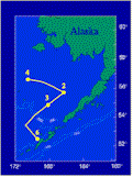 ecosystem observations this year, moorings were deployed at standard FOCI
sites in the southeastern Bering Sea during February. It was noted that Bering
Sea ice had retreated north of mooring 2 (see figure at left) by March. Measurements
at this mooring showed a cold, fresh water surface layer and warmer, more
saline water at the bottom. In spring, four cruises investigated shelf and
slope waters during the period April 14 to June 19. The purpose of these cruises
was to examine the spring phytoplankton bloom and its associated physical,
chemical, and biological oceanographic processes. During the cruises, moorings
were recovered and/or deployed at sites 2, 3, 4, and 6. Scientists conducted
biological and physical sampling using net tows and CTD casts at and between
mooring sites.
ecosystem observations this year, moorings were deployed at standard FOCI
sites in the southeastern Bering Sea during February. It was noted that Bering
Sea ice had retreated north of mooring 2 (see figure at left) by March. Measurements
at this mooring showed a cold, fresh water surface layer and warmer, more
saline water at the bottom. In spring, four cruises investigated shelf and
slope waters during the period April 14 to June 19. The purpose of these cruises
was to examine the spring phytoplankton bloom and its associated physical,
chemical, and biological oceanographic processes. During the cruises, moorings
were recovered and/or deployed at sites 2, 3, 4, and 6. Scientists conducted
biological and physical sampling using net tows and CTD casts at and between
mooring sites.
Spring conditions were well documented. Temperatures in the
southeastern Bering Sea were warmer than previous years, and
there was more storm activity. The level of thermal stratification
was less pronounced (the shelf was well mixed to 80m through
May) as a result. A recognizable spring phytoplankton bloom had
not started by June, and by the end of the season, no spring bloom
was evident in either the middle or outer shelf domains. Anomalous
conditions (see workshop page) prevailed again this summer with a second year's
coccolithophore bloom over the Bering Sea shelf from Bering Strait
to the Pribilof Islands. SeaWifs images revealed the presence of
aquamarine water (see figure at right) from July through September
resulting from light 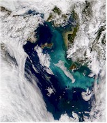 scattering from
coccolithophores.
Jellyfish were abundant
on the outer and middle
shelf, but less prevalent
in the inner domain. As
an indicator of unusual
circulation, the NSF
Inner Front cruise during
June caught offshore
euphausiids at the outer
ends of their Cape
Newenham and Nunivak
Island lines. Participants
on the July Oshoro Maru cruise reported that the distribution of
pollock seems low this year relative to the last four years. They also
noted the continuation of the coccolithophore bloom north of St.
Paul Island. By mid August shelf water had cooled. By early
September storm winds had deepened the mixed layer, and the
water was colder than at the same time last year. Sea bird
abundance was low, and those sampled were under weight. Birds
sampled on the Pribilofs in August were also undersized and there
were signs of reproductive failure. The coccolithophore bloom
extended from Nunivak Island to the Pribilof Islands and to
mooring site 2. Bristol Bay and the coastal regions were not
affected. Shelf waters were rich in nutrients, and there were
significant zooplankton as opposed to last year when
coccolithophores dominated. During mid September the bloom was
still prevalent, and project scientists sampled on either side of a
front separating typical Bering Sea water from bloom water.
scattering from
coccolithophores.
Jellyfish were abundant
on the outer and middle
shelf, but less prevalent
in the inner domain. As
an indicator of unusual
circulation, the NSF
Inner Front cruise during
June caught offshore
euphausiids at the outer
ends of their Cape
Newenham and Nunivak
Island lines. Participants
on the July Oshoro Maru cruise reported that the distribution of
pollock seems low this year relative to the last four years. They also
noted the continuation of the coccolithophore bloom north of St.
Paul Island. By mid August shelf water had cooled. By early
September storm winds had deepened the mixed layer, and the
water was colder than at the same time last year. Sea bird
abundance was low, and those sampled were under weight. Birds
sampled on the Pribilofs in August were also undersized and there
were signs of reproductive failure. The coccolithophore bloom
extended from Nunivak Island to the Pribilof Islands and to
mooring site 2. Bristol Bay and the coastal regions were not
affected. Shelf waters were rich in nutrients, and there were
significant zooplankton as opposed to last year when
coccolithophores dominated. During mid September the bloom was
still prevalent, and project scientists sampled on either side of a
front separating typical Bering Sea water from bloom water.
- Milestone (Q4): Understand coupled physical-biological interactions affecting Bering Sea/Shelikof Strait walleye pollock
survival and recruitment. (PMEL)
- Accomplishments: FOCI has developed conceptual models of
pollock survival for both Shelikof Strait (see figure below) and the Bering
Sea. Because research in Shelikof Strait started seven years before that
in the Bering Sea, the Shelikof model is more advanced. However, research
this year has increased our understanding of differences in ecosytem dynamics
between the two regions. For example, Bering Sea pollock eggs are found higher
in the water column and develop more rapidly at cold temperatures than those
in Shelikof Strait. Thus Bering Sea pollock eggs are more vulnerable to wind-driven
advection but, because of their shorter development time, are less prone to
predation.
 FOCI scientists collaborated with NMFS managers to begin incorporating FOCI's
understanding of biophysical factors on recruitment and predation mortality
of Shelikof Strait walleye pollock into NMFS operational models. Extensive
environmental time series collected and collated by FOCI quantify the dual
effects of climate forcing and species interaction for input to a NMFS Alaska
Fisheries Science Center stock assessment model. Results from the assessment
model provide guidance to the North Pacific Fishery Management Council.
FOCI scientists collaborated with NMFS managers to begin incorporating FOCI's
understanding of biophysical factors on recruitment and predation mortality
of Shelikof Strait walleye pollock into NMFS operational models. Extensive
environmental time series collected and collated by FOCI quantify the dual
effects of climate forcing and species interaction for input to a NMFS Alaska
Fisheries Science Center stock assessment model. Results from the assessment
model provide guidance to the North Pacific Fishery Management Council.
Strategic Plan Element: Advance Short-term Warning and Forecast Services
Objective: Improve Service Communication and Utilization.
Performance Measure: Advanced Emergency Management Technology and Information.
-
Milestone (Q3): Complete development of prototype operational deep-ocean tsunami detection system. (PMEL)
- Accomplishments: Four prototype systems for tsunami early
detection and real-time reporting
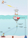 have
been developed and deployed over the past 14 months in the deep ocean, as
part of the U.S. National Tsunami Hazard Mitigation Program. The systems utilize
bottom pressure recorders
(BPRs) capable of detecting and measuring tsunamis with amplitude as small
as 1 cm in 6000 m of water, and the data are transmitted by acoustic modem
to a surface buoy, which then relays the information to a ground station via
satellite telecommunications. Excellent real-time sea level data were received
at PMEL during each deployment, proving the concept. Extended periods
of data loss were also experienced, however, and design improvements to increase
reliability are currently being implemented. have
been developed and deployed over the past 14 months in the deep ocean, as
part of the U.S. National Tsunami Hazard Mitigation Program. The systems utilize
bottom pressure recorders
(BPRs) capable of detecting and measuring tsunamis with amplitude as small
as 1 cm in 6000 m of water, and the data are transmitted by acoustic modem
to a surface buoy, which then relays the information to a ground station via
satellite telecommunications. Excellent real-time sea level data were received
at PMEL during each deployment, proving the concept. Extended periods
of data loss were also experienced, however, and design improvements to increase
reliability are currently being implemented.
Strategic Plan Element: Implement Seasonal to Interannual Climate Forecasts
Objective: Maintain and Improve Observing and Data Delivery Systems
Performance Measure: Percent of data from observing systems used in predictions; percent of observing system operational.
- Milestone(Q4): Maintain the TAO array portion of the ENSO observing system. The TAO moored array is expected to remain in place for a decade. Each of the
the 70 deep ocean moorings will be inspected, serviced, or replaced, as required, approximately twice yearly. (PMEL)
- Accomplishments: The Tropical Atmosphere Ocean (TAO) array is a key
element of NOAA's recently completed
 ENSO observing system and nearly 70 deep ocean moorings are maintained across the equatorial Pacific.
In FY98, the TAO array, along with other components of the ENSO observing
system, were converted to operational status through an act of Congress. ENSO observing system and nearly 70 deep ocean moorings are maintained across the equatorial Pacific.
In FY98, the TAO array, along with other components of the ENSO observing
system, were converted to operational status through an act of Congress.
The 1997-98 El Nino has been called "The Climate Event of the Century". It
was one of the strongest El
Ninos on record, with spectacular impacts on global weather variability
and Pacific marine ecosystems. TAO data were used to initialize and validate
model forecasts for the 1997-98 event, and to provide essential information
at a level of detail never before possible in real-time. Recently developed
ENSO forecast models, initialized with satellite and in-situ data from the
ENSO observing system, were correct in most cases in predicting that 1997
would be warm and the latter half of 1998 would be cold in the tropical
Pacific. This motivated disaster
preparedness, mitigation efforts, and other societal responses to developing
El Nino conditions on an unprecedented scale. It is expected that, as current
cold conditions continue to develop in the tropical Pacific, climate analysis
and forecast information will be likewise be valuable for planning purposes,
allowing us to translate scientific progress in climate research into societal
benefits worldwide.
 In
order to maintain the moored array, the TAO group participated in 9 different
cruises for 260 sea days on both NOAA and Japanese research vessels. A total
of 71 moorings were deployed including NextGeneration
ATLAS moorings at 16 sites in the array. These new moorings use inductive
coupling of subsurface sensors to the surface microprocessor and satellite
transmitter, eliminating the separate conducting cable of the older style
ATLAS. The simpler mooring design also makes for more efficient assembly,
deployment, and recovery. Use of updated electronics makes for higher temporal
resolution (10 minutes internally recorded), greater ocean temperature data
accuracy, and greater flexibility in adding nonstandard measurements (e.g.,
salinity, rainfall, radiation). Equatorial velocity measurements and key
upper ocean salinity measurements in the western Pacific have also continued
and have been used to validate coupled ocean-atmosphere ENSO prediction
models. The TAO Project is also working closely with JAMSTEC in their development
efforts of Japan's new TRITON
buoy. After a period of extensive testing and data comparison, TRITON buoys
will replace the ATLAS moorings at 9 sites in the western Pacific. In
order to maintain the moored array, the TAO group participated in 9 different
cruises for 260 sea days on both NOAA and Japanese research vessels. A total
of 71 moorings were deployed including NextGeneration
ATLAS moorings at 16 sites in the array. These new moorings use inductive
coupling of subsurface sensors to the surface microprocessor and satellite
transmitter, eliminating the separate conducting cable of the older style
ATLAS. The simpler mooring design also makes for more efficient assembly,
deployment, and recovery. Use of updated electronics makes for higher temporal
resolution (10 minutes internally recorded), greater ocean temperature data
accuracy, and greater flexibility in adding nonstandard measurements (e.g.,
salinity, rainfall, radiation). Equatorial velocity measurements and key
upper ocean salinity measurements in the western Pacific have also continued
and have been used to validate coupled ocean-atmosphere ENSO prediction
models. The TAO Project is also working closely with JAMSTEC in their development
efforts of Japan's new TRITON
buoy. After a period of extensive testing and data comparison, TRITON buoys
will replace the ATLAS moorings at 9 sites in the western Pacific.
Strategic Plan Element: Document, Predict, and Assess Decadal-to-Centennial Climate Change
Objective: Understand the Role of the Oceans in Global Change
Performance Measure: Implement in situ technologies for physical and chemical ocean observations.
- Milestone(Q4): Maintain and improve an observational system to detect and track the flux of heat and chemicals from the Earth's
interior to the deep ocean. (PMEL)
- Accomplishments: Within two weeks of the initial event,
 NSF/RIDGE and NOAA/VENTS investigators
were able to organize and carry outan opportunistic rapid response to an eruption
event detected by the SOSUS acoustic monitoring network. Experience accrued
during this rapid response endeavour will prove invaluable in responding to
future events in a timely manner.
NSF/RIDGE and NOAA/VENTS investigators
were able to organize and carry outan opportunistic rapid response to an eruption
event detected by the SOSUS acoustic monitoring network. Experience accrued
during this rapid response endeavour will prove invaluable in responding to
future events in a timely manner.
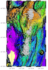
Beginning at 1200 GMT on 25 January 1998, intense seismicity was
detected in the northeast Pacific Ocean using the T-phase Monitoring
System developed by NOAA/PMEL to access the U.S. Navy's SOund
SUrveillance System (SOSUS).
The initial activity was located on the summit and southern flank of
Axial Seamount on the central Juan de Fuca Ridge, near 45 55'N and 130
00'W. The seismic activity lasted twelve days and included over 8,000 earthquakes
detected by SOSUS.
Using the Oregon State University research vessel WECOMA,
a rapid response effort was conducted from February 9-16. Despite continuous
25 to 40 knot winds, with gusts to 70 knots, and 10 to 18 ft. seas, WECOMA
conducted nearly continuous operations, surveying the rift zone in detail,
completing 16 vertical CTD casts, and deploying 8 ocean bottom hydrophones
(OBH) around the intersection of the south rift zone and the summit caldera;
the OBH deployment is the earliest that such instruments have been deployed
after a seismic event. After Axial operations were complete, a sound source
mooring was deployed at Thompson Seamount and two Tsunami moorings were
recovered on the return to Newport.
The CTD/water sampling stations were sufficient to document
extensive new venting at Axial Volcano. Very strong hydrothermal
signals were detected in the southern portion of the Axial Volcano
caldera, as well as at stations to the southwest of the caldera, with
hydrothermal discharge from the summit roughly an order of magnitude
greater than before the event. Plumes with temperature anomalies
approaching 0.20C and intense light attenuation values filled the south end of
the caldera, rising at least 200 m above bottom. Plume
advection to the southwest was in agreement with past current meter
measurements.
Methane and hydrogen concentrations of 600 and 200 nM, respectively,
occurred in the plumes at stations near the intersection of the south
rift zone with the caldera. Some vertical profiles were dominated by a
shallow (1200 to 1400 m) and/or a deep (1400-1550 m) maxima in
hydrothermal signals. A cast at the Ashes site revealed a strong plume with considerable vertical structure, extending from about 1200 m to the
seafloor (about 1570 m).
with considerable vertical structure, extending from about 1200 m to the
seafloor (about 1570 m).
Scanning Electron Microscope (SEM) examination detected
glass shards in samples from a hydrothermal plume, and along with other SEM
evidence, strongly suggested a lava eruption on the caldera floor,
probably centered in the southeast corner of the caldera.
This eruption is the first to occur in the presence of seafloor
monitoring instruments, with two Volcanic System Monitors in the
caldera, and three temperature sensor/current meter moorings arrayed
along the southeast corner of the caldera, exactly at the center of the
summit epicenter locations. These instruments, recovered during the
VENTS cruises from 30 July to 15 August on the NOAA Ship RONALD H. BROWN, will provide current flow information for calculating heat and
chemical fluxes from the caldera.
- Milestone (Q4): As part of NOAA's contribution to the National Ocean Partnership Program (NOPP), design, develop
and deploy a robust, deep-ocean, air-sea interaction mooring system near the site of Ocean Weather Station PAPA. (PMEL)
- Accomplishments: As part of the National Ocean Partnership
Program, PMEL has been funded to develop and deploy moorings in the North Pacific in collaboration with the University of Washington/Applied Physics Lab, Scripps Institution of Oceanography, NOAA/NESDIS, and the Naval Research Lab. The first of these moorings will be deployed at Ocean Station PAPA (50N, 145W) from the NOAA Ship Ron Brown on
a cruise from Victoria, BC to Seattle from 23 September to October 3, 1998.
This mooring will be in place for one year, then recovered and redeployed
in late 1999. A second site mooring site, nominally at 35N, 165W, will be
occupied in late 1999 with a similarly designed mooring. The two moorings
will sample contrasting climatic regimes of the subarctic gyre (PAPA) and
subtropical gyre. The PAPA mooring will extend the measurements at this site
which began in 1956, first as weather ship measurements (until 1981), then
as cruises 3-4 times a year along Line P conducted by the Institute of Ocean
Sciences (IOS) in Sydney, BC.
The rationale for this project can be summarized as follows:
- Substantial interannual to decadal variations in SST occur in the North
Pacific associated with El
Nino/Southern Oscillation (ENSO) and the Pacific Decadal Oscillation
(PDO), but they are not well understood;
- Anomalous SSTs in the North Pacific are highly correlated with the
Pacific North American (PNA) surface atmospheric pressure pattern and
with the climate over North America;
- Variations in North Pacific SSTs are well correlated with various
components of the ocean's ecosystem, including plankton and top
predators such as salmon;
- Progress in understanding and ultimately predicting these fluctuations
is hampered by lack of systematic time series observations in the upper
ocean of the North Pacific.
Much of the PMEL effort during the past year has been involved in the
mooring design, equipment acquisition, fabrication, testing, and
software development, and interaction with the partners. A robust
surface buoy and mooring have been designed for the high latitude
deployments with an emphasis on stability and reliability to withstand
the forces of typical winter storms. Instrumentation to measure surface
meteorology, subsurface temperature, salinity and velocity has been
integrated into a high capacity controller mounted in an instrument well
on the buoy. Real-time data telemetry will utilize the GOES Data
Collection System (DCS) with data retrieval via a 5-m antenna and a
Direct Readout Ground Station (DRGS) that was recently acquired at PMEL.
A nearby ATOC mooring will communicate with the surface buoy via an
acoustic modem, and a compressed file of acoustic travel time
information will be transmitted via GOES. In addition, PMEL will
deploy an upward looking 153.6 kHz acoustic Doppler current profiler
(ADCP) at Station P.
|


