 |
 |
FY 2001 Operating Plan for PMELGOAL: SUSTAIN HEALTHY COASTSObjective 3: Foster Well-planned and Revitalized Coastal Communities That Are Compatible with the Natural Environment, Minimize the Risk from Natural Hazards, and Provide Access to Coastal Resources for the Public Use and Enjoyment Performance Measure: Number of improved information management tools developed to assist coastal hazard mitigation
Efforts: NOAA serves as the lead agency for the U.S. National Tsunami Hazard Mitigation Program, a partnership with the five Pacific state, the U.S. Geological Survey, and the Federal Emergency Management Agency. PMEL's Center for Tsunami Inundation Mapping Efforts (TIME) coordinates and assists the states in the development of inundation maps for coastal communities at risk that are identified and prioritized by the states. This years work was conducted in collaboration with the U. Southern California, the Oregon Graduate Institute, state geoscientists, and state emergency management officials and staff. Customers: The inundation maps are produced at the request of state emergency management officials and completed maps are delivered to them in the form of electronic data files, imagery, and hard copy. The products derived from these maps, such as evacuation maps, are then delivered to coastal residents in the form of brochures, handouts and other educational materials. Significance: Inundation maps are an essential emergency management tool and the starting point for pre-disaster hazard assessment, response preparation, recovery planning, and educational programs. Inundation maps provide the primary guidance for the production and publication by the states of evacuation maps which include preferred and alternative routes, safe gathering locations, and important infrastructure information such as hospital, police and fire station locations. Success: Five inundation maps were completed: Kodiak, AK; South San Diego, CA; Honolulu/W. Oahu, HI; and Clallam and Jefferson Counties, WA. These maps encompass approximatley 28 communities at risk of tsunami inundation. In addition, two course-grid simulations, suitable for evaluating the need for large-scale inundation maps, were completed for the Kona Coast, Island of Hawaii, and for Puget Sound, Washington. Next Steps: The states have identified and prioritized eight additional coastal areas that require inundation mapping, and PMEL/TIME will assist and coordinate the development of computational grids, the specification of credible "worst-case" scenarios, the numerical simulation of these cases, and the production of the inundation maps.
Purpose: NOAA conducts basic oceanographic research to understand the impacts of the Earth's largest volcanic system, the global network of volcanically active seafloor spreading centers, on the ocean's physical, chemical, and biological environments. Efforts: Four years ago, the NOAA
Vents program initiated a focused, long-term physical, chemical,
and biological monitoring program within the caldera of an active, mile-deep
submarine volcano located about 300 miles off the Oregon coast. This
effort resulted in the establishment of the world's first deep-ocean
observatory, now called NeMO
(New Millennium Observatory). NeMO now hosts a variety of in-situ
sensing systems that are producing unique data time series that allow
oceanographers, for the first time, to begin to quantify newly discovered,
highly dynamic ocean impacts of both quasi-steadystate Customers: This research is a unique and integral part of a national oceanographic research effort to discover and understand natural ocean variability which, through processes originating at the bottom of the ocean, affects the Earth's entire hydrosphere. This research also provides NOAA with the basis upon which to develop an informed perspective on natural variability of such ocean environmental regimes as biological nutrient and heat budgets and cycles. The program has direct, complementary links to efforts sponsored by the National Science Foundation and the research also provides a framework for implementation of research sponsored by the new NOAA Ocean Exploration program. Significance: In 1993, Vents scientists (both NOAA and their non-NOAA collaborators) discovered that there was a vast subseafloor microbial ecosystem in regions heated by volcanic activity. The microorganisms which inhabit this ecosystem are called extremophiles because they exist under extreme conditions of pressure, heat, and chemistry. These microorganisms have great, but as yet largely unexplored, potential for utilization in development of new pharmaceuticals and in catalyzing a wide variety of industrial, manufacturing, and environmental remediation processes. The principal goal of the NeMO observatory is to conduct in situ, long- term experiments that will provide biological oceanographers with sufficient quantitative information to allow them to achieve such goals as establishing the exact physical and chemical nature of the ecosystem, establishing the ecosystem's microbial species diversity, and development of novel ways to both sample the ecosystem's microbes and to culture them in land laboratories. Success: Experiments to achieve the objectives referred to above
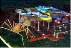
achieved a major breakthrough in FY 2001. Near the beginning of FY 2001,
a unique instrument system was deployed at NeMO which, for the first
time ever in the deep ocean, allowed shore-based scientists to acquire,
in near- real-time, temperature and photographic data at an active hydrothemal
vent site. The instrument system, call NeMO
Net, consisted of the seafloor sensor systems, acoustically linked
to a nearby surface mooring, which routinely transmitted Next Steps: Efforts are now underway to augment the NeMO Net system with the first deep- ocean, interactive chemical sampling system. The system will measure pH, H2S, and temperature as well as take and preserve samples of seawater for later chemical and microbiological analyses. This Remotely Activated Sampler will enable oceanographers to obtain, for the first time, samples on demand during initial stages of an eruption and seismic swarms. GOAL: BUILD SUSTAINABLE FISHERIES Objective 1: Eliminate and prevent overfishing and overcapitalization. Performance Measure: By 2005, 40% (86 of 269) fewer overfished fisheries
Purpose: The Bering Sea produces nearly half the nation's seafood and is critical habitat for many marine mammals and seabirds, including the endangered Steller sea lion. Modern fisheries managers increasingly rely on results from ecosystem research in addition to survey-based approaches that have been used in the past. Given broader ecosystem knowledge, resource managers can practice effective multi-species stewardship rather than traditional single-species management. The transfer of information from research to management is critical to optimize balance between conservation and use of natural marine resources. Efforts: Fisheries-Oceanography Coordinated Investigations (FOCI), specifically the Southeast Bering Sea Carrying Capacity (SEBSCC) program, has a goal to develop and test annual indices of Bering Sea pre-recruit (age-1) pollock abundance. Recent research has documented the changing nature of the Bering Sea, especially the large interannual variations in the physical and biological environment. For the seventh consecutive year, FOCI maintained a key biophysical mooring on the southeastern Bering Sea shelf to measure physical, chemical, and biological variability. This mooring provides the only continuous, long-term observations of ocean currents, temperature, salinity, nutrients, and primary production in the Bering Sea. Interpretations of these measurements with respect to other ecosystem findings enable scientists to elucidate relationships between oceanographic conditions and the biological environment. Such relationships are the basis for a science-based forecast methodology.
SEBSCC has created an Indices Working Group of Bering Sea scientists for the explicit task of casting the concepts suggested by the switch model and Oscillating Control Hypothesis into a mathematical construct. The construct will lead directly to annual indices of pre-recruit (age-1) pollock that is one of the program's goals. To complete the transfer of information from science to managment, the resulting indices will be incorporated into the procedure used by the National Marine Fisheries Service to provide guidance to resource managers. Coincident with efforts to develop a tool for fisheries resource management, FOCI also convenes annually a scientific panel to synthesize information on the physical and biological environments of the Gulf of Alaska, Aleutian Islands, and Bering Sea. This information is published in the Ecosystems Considerations chapter of the annual "Stock Assessment and Fishery Evaluation" report for the North Pacific Fishery Management Council. Customers: FOCI disseminates information to a wide variety of customers: students, scientists, fishermen, educators, and managers. Principal among these are the National Marine Fisheries Service Resource Ecology and Fisheries Management Division and the North Pacific Fishery Management Council, the body responsible for governing the regional fishing industry. FOCI communicates to the council through the National Marine Fisheries Service's stock assessment and stock forecast personnel and documents. Significance: Several years ago, in the wake of the closure of the New England fishery, the North Pacific Management Council adopted a holistic, ecosystem approach to fishery management. FOCI is one of only a few research programs in the world to forecast abundance and is the chief program that supplies scientific information to the council. FOCI contributes to a summary of annual ecosystem information that is delivered to the North Pacific Management Council as part of the yearly Stock Assessment and Fishery Evaluation Report. Pollock-specific information is transmitted in the form of FOCI's annual recruitment forecast. The initial forecast, developed for the Shelikof Strait, Gulf of Alaska fishery, was made nine years ago. This forecast is the only guidance available during the first year of any pollock year class, and as such is invaluable to management. A similar forecast for Bering Sea pollock is eagerly awaited by the National Marine Fisheries Service and the North Pacific Fishery Management Council. Success: The Bering Sea biophysical mooring was deployed successfully for FY 2001. Funds have not been forthcoming, however, to keep this mooring in operation after the second quarter of FY 2002. Much of the research, based on measurements from that mooring and other projects, that forms the basis for the switch model, Oscillating Control Hypothesis, and indices development has passed peer review and is published or will be soon. Much of this research will appear in an upcoming special issue of Deep-Sea Research II (Topical Studies in Oceanography). Initial efforts and plans by the SEBSCC Indices Working Group are described in a draft report (PDF document) of their first meeting, held during June 2001. FOCI's scientific panel contributed to "Ecosystem Considerations for 2001" (PDF document) that is a chapter of the 2001 Stock Assessment and Fishery Evaluation report. Topics analyzed and presented for education of the North Pacific Fishery Management Council included interannual variability of atmospheric forcing, seasonal rainfall at Kodiak, wind mixing in the western Gulf of Alaska, and, for the eastern Bering Sea shelf, ice extent and timing, water-column temperature cycling, timing of the last spring storm, and cross-shelf advection. Next Steps: Researchers have not been successful in attracting funding to continue the Bering Sea biophysical moorings during 2002. At this time, it appears that measurements will cease next spring. FOCI's scientific panel is reviewing the year's developments in preparation for the 2002 ecosystem discussion for the North Pacific Fishery Management Council. SEBSCC's other working groups, Synthesis and Pribilof Islands, will hold their initial meetings soon. Information generated by these groups will be useful to the Indices Working Group. The expected delivery time for Bering Sea indices of pre-recruit (age-1) pollock abundance is FY 2003. GOAL: ADVANCE SHORT-TERM WARNING AND FORECAST SERVICES Objective 3: Enhance observations and prediction
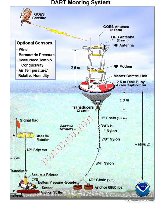
Purpose: PMEL's Deep-ocean Assessment and Reporting of Tsunamis (DART) Project is an effort to directly measure tsunami energy propagating towards coastal communities to increase the speed and accuracy of tsunami warnings and to reduce costly false alarms that undermine the credibility of the warning system. Efforts: The early recognition that improvements in the timeliness and accuracy of tsunami warnings were possible led PMEL scientists to conceive a plan to measure tsunami wave energy in the open ocean rather than at shore-side tide gauges. Deep water measurements near the tsunami source increase the time available to warn vulnerable communities and improve accuracy because the wave energy is not being influenced by shallow water and shore-based effects. An added benefit is that observations can also be used as a basis for sounding the "all clear" following an event, allowing the deployment of rescue personnel and the safe return of affected people to their homes and businesses.
Deployments of prototype DART systems began in 1998. In 2001, a 6-mooring network designed to provide early warning to the United States West Coast and Hawaii was completed. Customers: Primary users of DART data are NOAA's Pacific Tsunami Warning Center and the West Coast and Alaska Tsunami Warning Centers. These centers receive DART data directly via satellite downlink. Secondary users include the tsunami research and hazard mitigation community, including state and local emergency managers, and academic institutions. Additional customers may include individuals conducting research on ocean tides and other low frequency sea level phenomena. Ultimately, the most important customers are the people who live and work in coastal communities at risk from tsunamis. DART data is disseminated via the World Wide Web at http://tsunami.pmel.noaa.gov/dart/qc/WaveWatcher/ Significance: The DART Project is an effort of the U.S. National Tsunami Hazard Mitigation Program to develop early tsunami detection and real-time reporting capability. These data enable a more direct and rapid assessment of the tsunami hazard and, when coupled with model forecasting tools, provide a more accurate prediction of the impact on specific coastal communities. For example, Hawaii Civil Defense must make evacuation decisions within one hour of a large earthquake occurring in the Alaska Aleutian Subduction Zone. DART stations between this zone and Hawaii provide tsunami measurements within this critical time frame so that potentially destructive tsunamis will be more reliably identified, thus reducing the number of unnecessary evacuations due to false alarms. An added benefit of the real-time DART data stream is continued offshore tsunami monitoring. Dangerous conditions can persist for several hours after the first wave strikes a community because very large tsunamis can have periods as long as an hour and the largest wave may arrive as late as the third or fourth in a series. Continued offshore tsunami monitoring provides important guidance for decision-makers, who must evaluate the risk of deploying rescue and recovery personnel and equipment and, when the area is safe for the return of residents, sound the "all clear." Success: Mooring technology developed at PMEL has now been shown to be sufficiently robust and reliable to withstand the rigors of year long deployments in a harsh environment. Acoustic modem data link improvements made and tested in a 2000 prototype, and incorporated in all network moorings, have greatly reduced problems inherent in prior systems. All systems are returning data at a rate of 95% or better. Detection algorithm software has responded correctly to recent events. No false system triggers have occurred This milestone has thus been completed with the successful establishment of the last station in the DART tsunami monitoring network. Next Steps: The planned 6-station DART network to provide early detection and measurement of tsunamis generated in the primary source regions that threaten U.S. coastal communities is complete. PMEL is now transitioning the operation and maintenance of the DART system to NOAA's National Data Buoy Center, to be updated in three years. The transition from an experimental network to an operational network will be a testament to the project's overall success and value. GOAL: IMPLEMENT SEASONAL TO INTERANNUAL CLIMATE FORECASTS Objective 2: Maintain and Improve Observing and Data Delivery Systems Performance Measure: Increase the cumulative number of ocean observations that are critical for improving seasonal-to-interannual climate analyses and forecasts.
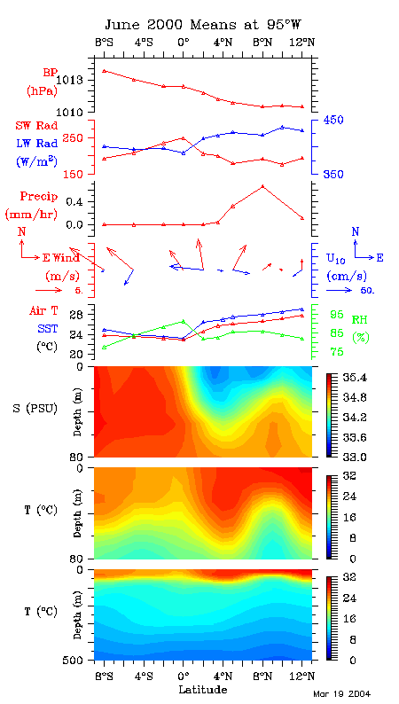
Purpose: The TAO/TRITON Array is a primary component of the ENSO Observing Array. As such it provides realtime ocean and atmosphere observations for use in climate prediction. Enhancement of the array's measurements to include ocean current, solar radiation, and barometric pressure measurements enables the estimate of heat, moisture and momentum fluxes, improving our understanding of the oceanic boundary forcing. High temporal resolution data from the moorings allow computation of the fluxes which couple the atmosphere and ocean. Efforts: The seven existing moorings along 95W meridian now include the enhanced sensor suite. Three additional "enhanced" moorings have been deployed as part of the Pan American Climate Studies (PACS) along 95W. Daily mean measurements are received in real time and higher temporal resolution data in delayed mode. Customers: In general, operational TAO data are delivered via the GTS to operational centers throughout the world. Researchers, policy makers, students and the general public also have access to the data though the WWW. Some enhanced data are available though the web, and all will be shared with collaborators in PACS. These high-resolution flux data and in-situ open- ocean precipitation and radiation data provide unique opportunities for various investigations, eg., satellite verification. Significance: PACS is a multi-institutional program focusing on the improvement of operational Pan-American seasonal-to-interannual climate prediction, and, in particular, the improvement of warm season rainfall forecasts over the Americas. The enhanced TAO array will provide a large-scale framework for EPIC2001, an intensive process study planned for this region in 2001. Success: All moorings along 95%W have been instrumented
with the enhanced sensors and the moorings have provided high quality
data. Scientific analyses of the data are underway, and initial results
will be highlighted at the International Flux Workshop in May 2001 in
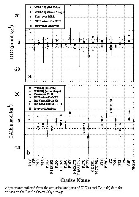
Washington, DC. Next Steps: Enhanced measurements along 95°W will continue through 2003. Some of the enhanced measurements will be extended to other mooring sites in the array. GOAL:DOCUMENT, PREDICT, AND ASSESS DECADAL-TO-CENTENNIAL CHANGE Objective 1: Characterize the Forcing Agents of Climate Change Performance Measure: Public release of Pacific carbon data set that is internally consistent to within ± 3 µmol/kg Subject: Carbon dioxide: global and regional sources and sinks
Purpose: NOAA bears the primary national responsibility for determining the sources and sinks for CO2 in the atmosphere and oceans Efforts: The global CO2 survey was conducted
as a cooperative effort between the Department of Energy (DOE), the
World Ocean Circulation Experiment (WOCE), the Joint Global Ocean Flux
Study (JGOFS), the National Oceanographic and Atmospheric Administration's
Ocean Atmosphere Carbon Exchange Study Customers: The primary customers for these data products are the atmospheric and ocean carbon modeling community. Significance: Inventories of natural and anthropogenic CO2 in the oceans are required for assessing the ocean's role in sequestering atmospheric CO2. These estimates will be used to infer the rate of anthropogenic CO2 uptake in the oceans and to evaluate numerical ocean carbon models. These estimates also provide an important benchmark against which future observational studies will be compared. Success: We have measured the distribution of anthropogenic
CO2 from 26 cruises in the Pacific Ocean. Anthropogenic CO2
concentrations in the Pacific reach a maximum value of about 50 µmol
kg-1. The highest concentrations (typically 40-45 µmol kg-1) are
found in the subtropical surface waters. These surface concentrations
generally agree with expected values based on thermodynamic considerations
and the observed atmospheric CO2 history. The distribution
of anthropogenic CO2 in the ocean interior is similar to
the distribution of other anthropogenic tracers in the central Pacific.
The deepest penetration of anthropogenic CO2 is found at
about 50°S associated with the subtropical convergence. The shallowest
penetration is found just north of the equator. The relatively shallow
penetration of anthropogenic CO2 in the North Pacific is
in strong contrast to the Atlantic distribution where anthropogenic
CO2 has penetrated all the way to the bottom in the northern
high latitudes. These differences result from the lack of significant
deep water formation in the North Pacific. The basin-wide distribution
of anthropogenic CO2 can be summarized with a map of the
anthropogenic CO2 column inventory. The highest inventories
are |
About us | Research | Publications | Data | Theme pages | Infrastructure |
| US Department of Commerce | NOAA | OAR | PMEL Pacific Marine Environmental Laboratory NOAA /R/PMEL 7600 Sand Point Way NE Seattle, WA 98115 |
Phone: (206) 526-6239 Fax: (206) 526-6815 Contacts Privacy Policy | Disclaimer | Accessibility Statement | oar.pmel.webmaster@noaa.gov |
|
 and
episodic volcanic and hydrothermal processes. These impacts include
effects on both micro- and macro-biological communities that are uniquely
associated with volcanically active areas of the ocean floor.
and
episodic volcanic and hydrothermal processes. These impacts include
effects on both micro- and macro-biological communities that are uniquely
associated with volcanically active areas of the ocean floor. 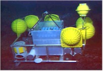 data
to satellites and thence, via the Internet, to laboratory scientists.
Another very important aspect of NeMO Net was that it also allowed shore-based
personnel to both query the seafloor instrument package and to command
the sensors to perform specific tasks. Commands to the NeMO Net package
on the seafloor could be given by anyone with authorized access via
the Internet. This non-hardwired, interactive two-way communication
with deep-ocean instrument systems had never been accomplished before.
The system performed flawlessly through the entire year and resulting
temperature records and biological photos are now being analyzed. Initial
observations indicate that days- to month-long temperature variations
may be correlated with changes in biological activity near the active
vent. The success of the NeMO Net experiment opens the door to even
more sophisticated experiments that will result in new discoveries about
the microbial ecosystem.
data
to satellites and thence, via the Internet, to laboratory scientists.
Another very important aspect of NeMO Net was that it also allowed shore-based
personnel to both query the seafloor instrument package and to command
the sensors to perform specific tasks. Commands to the NeMO Net package
on the seafloor could be given by anyone with authorized access via
the Internet. This non-hardwired, interactive two-way communication
with deep-ocean instrument systems had never been accomplished before.
The system performed flawlessly through the entire year and resulting
temperature records and biological photos are now being analyzed. Initial
observations indicate that days- to month-long temperature variations
may be correlated with changes in biological activity near the active
vent. The success of the NeMO Net experiment opens the door to even
more sophisticated experiments that will result in new discoveries about
the microbial ecosystem.


