|
 |
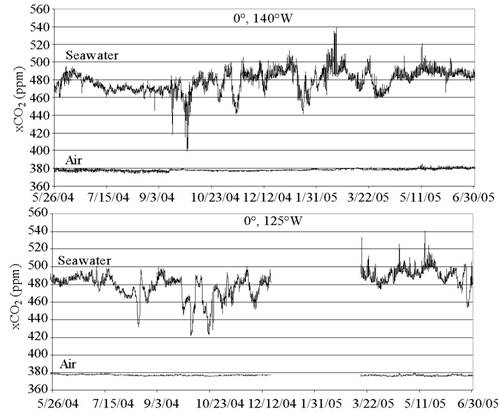
FY 2005 Operating Plan for PMELMission Goal: Protect, Restore, and Manage the Use of Coastal and Ocean Resources through an Ecosystem Approach to ManagementNOAA Program Matrix: Ecosystem ResearchProgram Manager: Leon Cammen Major Activity: Vents Objective: Understand and describe seafloor processes and how hydrothermal vents affect the ocean environment. NOAA Performance Measure: Extent of coastal, ocean, and Great Lakes ecosystems explored, mapped, characterized, and inventoried and publicly available. Responsible Laboratory and Manager: PMEL, John Lupton Research or Project Milestone: Complete field campaign to observe and sample deep-ocean organism living in chemosynthetic and /or microbiological ecosystem in and around active volcanic and hydrothermal systems in the Pacific Ocean. Quarter Due: 2nd quarter, 2005 Purpose: This project, with funding assistance from NOAA’s Ocean Exploration Program Office, addresses NOAA’s ecological observing system, collecting integrated ecological and physical data to promote understanding of the factors that affect the protection of marine habitats, including coral reefs. Field work was directed at the first sampling and observation of hydrothermal ecosystems in US EEZ waters along the Mariana Arc (Territory of Guam and the Commonwealth of the Northern Mariana Islands). The majority of these ecosystems, ranging in depth from 10s of meters to >1600 m, were discovered by Vents work in 2003. The 2004 cruise was designed to describe and collect biological samples (macro- and micro-fauna), the hydrothermal fluids that support these ecosystems, and the geological environment in which they flourish. Efforts and Results (to date): A total of 14 Remotely Operated Vehicle dives were conducted at seven volcanoes. High resolution seafloor mapping and hydrographic surveys were also done at each volcano. Biological specimens, hydrothermal fluids, and geological samples were collected at active vent sites. Notable results include (1) the first observation and sampling of an ongoing volcanic ash eruption, (2) discovery of overlapping chemosynthetic and photosynthetic (including corals) ecosystems on a shallow volcano, (3) discovery of a vent site discharging extraordinarily high concentrations of liquid CO2 bubbles, one of only three such sites known on the sea floor. Each active hydrothermal site was characterized by a unique biological assemblage linked to the depth, hydrothermal fluid chemistry, and geological environment. These studies represent the first systematic inventory of volcanic arc submarine ecosystems ever conducted, opening a new area for NOAA Ecosystems Research. The investigators from this cruise presented eleven papers highlighting cruise results at the 2004 AGU Fall Meeting. A journal article is in preparation for submission to Nature: R. W. Embley et al., "Eruptive Activity at a Submarine Arc Volcano." This project is continuing in FY 05 with the first observation and sampling of hydrothermal ecosystems at several volcanoes along the Kermadec Arc in the southwest Pacific, in cooperation with the Hawaiian Undersea Research Laboratory (HURL) and NOAA’s Ocean Exploration Office. Customer(s): NMFS (groundfish habitats, Coral Reef Program), NOS (improved charting around volcanoes for tsunami research), DOE (CO2 sequestration), scientific community (peer-reviewed publications), public (web-based outreach and reports, cruise logs, lesson plans). -------------------------------------------------------------------------------------------------------------------------- NOAA Program Matrix: Ecosystem OsbervationsProgram Manager: Steve Murawski Major Activity: Fisheries Oceanography Coordinated Investigations (FOCI) Objective: Monitor and observe ecosystem change in the Bering Sea and North Pacific Ocean leading to better prediction of fish stocks. NOAA Performance Measure: Percentage of coastal and marine ecosystems with adequate assessments and forecasts for management. Responsible Laboratory and Manager: PMEL, Dr. Phyllis Stabeno Research or Project Milestone: FOCI: Complete assessment of the impact of sea ice, the primary climatic forcing function of the ecosystem, on the Bering Sea by: 1) extending ice time series backward in time through the assimilation of sporadic historical observations into models, 2) relating changes in ice cover to changes in ecosystem composition, and 3) developing a prototype ecosystem prediction model. Quarter Due: 4th Purpose: The Bering Sea is a major economic and environmental resource for the United States, supporting approximately half the US catch of fish and shellfish on an annual basis, and immense populations of marine birds and mammals. It is also a cultural resource for the many Native Alaskan communities that live on its margin. Sea ice is a crucial aspect of the physical environment of the Bering Sea, directly impacting the temperature, salinity and structure of the water column, the timing of the spring phytoplankton bloom, and distribution of fish and shellfish. Efforts and Results (to date):1.Weekly ice extent and concentration data is only available since 1972 with the advent of satellite oceanography. To better understand the impact of ice on ecosystem, we undertook a project to extend the ice coverage estimates back to 1960 using available data and models. The model presently employs a 10-km resolution grid which spans the entire Bering Sea, based on the Regional Ocean Modeling System (ROMS). ROMS is a primitive equation, free-surface model constructed with curvilinear-orthogonal horizontal coordinates and stretched vertical coordinates (further details available at the ROMS website: http://marine.rutgers.edu/po/index.php?model=roms&page=). The stretched vertical coordinate system (here, 30 levels) is utilized for enhanced resolution of both surface and bottom boundary layers. The full domain of the model includes the Northeast Pacific (NEP) from Baja California through the Bering Strait, and extends from the coast to ~2000 km offshore. This domain is nested within a larger one, spanning the entire North Pacific at ~40-km resolution. This version of ROMS has been expanded to include ice dynamics as implemented by P. Budgell. Our ice hindcasts are driven by NCEP winds and heat fluxes, with corrections to the NCEP shortwave flux based on meteorological mooring data from the Bering Sea. In collaboration with E. Curchitser, we have developed model hindcasts for the period 1996-2003 which we compared to satellite observations. This model does an excellent job of capturing the observed interannual variability of ice cover in the Bering Sea (see Figs 1 and 2 in our website http://www.pmel.noaa.gov/foci/efoci_icemodels.shtml). We also have completed and posted on our web site hindcasts for 1960-1969. A finer-scale (3-km) version of the Bering Sea model will be developed in the coming year, contingent on the availability of funds. This newer version will include tidal dynamics. 2. During the last decade, the southeastern Bering Sea shelf has undergone a marked warming of ~3°C that is closely associated with the marked decrease of sea ice over the southeastern Bering Sea Shelf. These shifts in the physical environment of the Shelf can be attributed to a combination of mechanisms, including: a strong northward wind anomaly which has persisted since 2000; a shorter ice season caused by a later fall transition and/or an earlier spring transition; an increased flow through Unimak Pass during winter which introduces warm Gulf of Alaska water onto the southeastern Bering Sea Shelf; and the feedback mechanism of warmer ocean temperatures during the summer which delays the southward advection of sea ice during winter. Warming of the eastern Bering Sea Shelf has profound influences on the ecosystem of the Bering Sea. The spring phytoplankton bloom is occurring later because of the lack of sea ice. Zooplankton biomass over Bering Sea shelf has decreased since 2000. There appears to be a northward shift in subarctic species such as snow crab. 3. We have developed a conceptual model that relates the presence/absence of sea ice to ocean temperatures, timing of the spring bloom and the range of some species of fish. Customer(s): As noted earlier, understanding and predicting sea ice extent and concentration is critical to managing the Bering Sea ecosystem. This work will contribute to improved predictions by fisheries managers. -------------------------------------------------------------------------------------------------------------------------- NOAA Program Matrix: Ecosystems ObservationsMajor Activity: FOCI NOAA Performance Measure: Percentage of coastal and marine ecosystems with adequate assessments and forecasts for management. Responsible Laboratory and Manager: OAR/PMEL, Dr. P.J. Stabeno, and NMFS/Alaska Fisheries Science Center, Dr. J. Napp. Research of Project Milestone: (IOOS Milestone) Acquire and test technology to enable real-time data transmission from subsurface sensors on NOAA Observing System biophysical moorings, Phyllis Stabeno, Jeff Napp. Quarter Due: 4thPurpose: Zooplankton is a critical component of all ecosystems, providing the trophic link between primary production and apex predators such as marine mammals, seabirds and fish. There is large temporal variability in zooplankton abundance and production. Superimposed on quasi-decadal and interannual variation in abundance are diel, seasonal and annual cycles. Thus, capturing a true representation of the food available for higher trophic levels usually requires many samples to average over these sources of variability. In the Bering Sea and Gulf of Alaska ecosystems, it is difficult to obtain sufficient shiptime to achieve the critical levels of net-sampling needed to detect interannual and quasi-decadal shifts in abundance (e.g. regime shifts). Yet this is exactly what is required for NOAA’s ecosystem approach to management. Efforts and Results (to date): Over the last several years, acoustic measurements of zooplankton have been successfully made from moorings in the Gulf of Alaska. The new moored instruments have proven themselves to be reliable, but real-time reporting of such data is in its infancy. Without real-time reporting, data are only available after recovery of the moorings, which is often too late for inclusion for the management’s prediction and assessment process for that year. This year we designed and developed real-time reporting capabilities for the 8-frequency acoustic zooplankton monitor in use on our moorings (TAPS-8; BAE Systems, Inc). The zooplankton real time reporting system is designed around the Tracor Acoustic Profiling Systems 8-channel (TAPS-8) instrument. The testing preformed at PMEL in 2005 used the TAPS-8 in a closed real-time system. The TAPS-8 sensor, an acoustic modem, and battery are mounted on a subsurface float. A second acoustic modem (Link Quest), mounted on a surface buoy, receives data from the TAPS-8 sensor and delivers it to a microprocessor/controller, also mounted on the surface buoy. An updated GPS location and time is integrated into the data stream. The data is then transmitted via Iridium satellite to PMEL in real-time. An advantage of using Iridium is that scientists can send instructions back to the sensor, using the same communications link, to change the sampling rate, etc. In September, PMEL and AFSC scientists successfully tested this system in Lake Washington. Photos of the equipment and deployment can be found on our web page http://www.pmel.noaa.gov/foci/efoci_TAPSzooplankton.shtml The subsurface physical structure used in this test is designed to be similar to that which is planned for spring, 2006 mooring operations by the OAR/NMFS Fisheries Oceanography Coordinated Investigations (FOCI) program. The 40” syntactic foam buoy and stainless frame carries the TAPS-8 instrument and battery attached to the buoy frame with the Link Quest Modem and battery mounted in the surface buoy. In the September tests, TAPS successfully collected data and transmitted the data through the subsurface modem to the surface modem. The surface interface system then organized the data and transmitted it via Iridium satellite to PMEL, where the data were recorded. We have acquired and tested technology to enable real-time data transmission from subsurface sensors on NOAA Observing System biophysical moorings, We will deploy this instrument with its real time capabilities on the primary biophysical mooring in the Bering Sea next spring. Customers: The ability to deliver real-time subsurface data increases the value of the information NOAA passes on to the Regional Fishery Managers. Real-time subsurface data is also valuable to the fishing fleets. For instance, real-time subsurface data allows fishermen to time their activities to maximize the value of Pollock roe. -------------------------------------------------------------------------------------------------------------------------- Mission Goal: Protect, Restore, and Manage the Use of Coastal and Ocean Resources through an Ecosystem Approach to ManagementNOAA Program Matrix: Climate ForcingProgram Manager: Daniel Albritton Major Activity: Global carbon cycle Objective: Monitor and understand atmospheric trends in CO2 and oceanic and terrestrial emission and uptake processes to support policy decisions in carbon management to mitigate unwanted effects in climate change. NOAA Performance Measure: Assess and model carbon sources and skins globally (GPRA discontinued in FY06) OAR Performance Measure: Determine the change in the inventory of anthropogenic carbon dioxide in the North Atlantic (by 2007) and the North Pacific (by 2010) oceans over the previous decade to +/- 20%. Responsible Laboratory and Manager: PMEL, Christopher Sabine Quarter Due: Q3Purpose: The moored pCO2 program is a component of NOAA’s Plan for Building a Sustained Ocean Observing System for Climate and directly addresses key element 8) Ocean Carbon Monitoring Network, as outlined in the program plan. It also provides a value added component to elements 4) Tropical Moored Buoy Network and 6) Ocean Reference Stations. Within the Ocean Carbon Monitoring Network element, there are three major related components: repeat hydrographic sections, underway surface pCO2 measurements, and moored pCO2 measurements. Each component addresses a different timescale of variability. The moored pCO2 program is designed to assess the short-term variability that cannot be accomplished with shipboard measurements. Obtaining long-term records of these high-resolution measurements allows a full integration of the short-term variability into the longer-term records obtained from the other elements of the CO2 program. In particular, the moored pCO2 data will directly contribute to the production of regional CO2 flux maps and is being examined as a component of a new breed of data assimilation models that include estimates of carbon distributions and fluxes. Efforts and Results (to date): Since December 1996, the Monterey Bay Aquarium Research Institute (MBARI) has maintained bio-optical and chemical instrumentation on two moorings in the Equatorial Pacific in collaboration with NOAA/PMEL. In 2002 NOAA’s Global Carbon Cycle (GCC) program funded a proposal to begin transferring the pCO2 system technology developed at MBARI to PMEL with the idea that PMEL would begin developing a pCO2 mooring network. In 2004, the moored CO2 program was picked up by the Office of Climate Observations as part of the ocean observing system for climate. The first two moored pCO2 systems built at PMEL were successfully deployed in May of 2004. They collect measurements of surface water and atmospheric pCO2 every 3 hours and transmit the data back to the laboratory every 24 hours. This quarter marks the completion of the first full year of data collection at these sites. The system at 0°, 140°W had 100% data return for the first year and the system at 0°, 125°W was operating without problems until December 19, 2004 when the entire buoy was lost at sea. Another buoy and pCO2 system was deployed at 0°, 125°W on March 16, 2005 and has operated successfully since that time. Fig. 1 shows that these moorings documented variability in surface seawater values over the full range of timescales ranging from semi-diurnal to inter-annual.
Figure 1: Plot of surface seawater and atmospheric CO2 mole fraction (xCO2) as a function of time at 0°, 140°W and 0°, 125°W. Since the deployment of the first two PMEL systems in 2004, we have now deployed additional systems at 0°, 170°W, off of Hawaii at 22°N, 158°W, and off Japan at 32°N, 145°E. The moored pCO2 network is still in its infancy, but the PMEL CO2 program hopes to expand into a global network of surface ocean and atmospheric CO2 observations that will make a substantial contribution to the production of CO2 flux maps for the global oceans. Customer(s): Ocean carbon scientists, climate modelers, data assimilation modelers, public (e.g. web-based outreach and reports) -------------------------------------------------------------------------------------------------------------------------- NOAA Program Matrix: Climate ForcingProgram Manager: Daniel L. Albritton NOAA Performance Measure: Reduced uncertainty in model simulations of the influence of tropospheric ozone and aerosols on climate (proposed GPRA for FY 2006) Responsible Laboratory and Manager: AL/A.R. Ravishankara; OGP/Kea Duckenfield; PMEL/TimeBates. Quarter Due: 4th Purpose: Aerosols and tropospheric ozone are two of the most important climate forcing agents, and the magnitude of their contribution to climate forcing is highly uncertain. In addition, aerosols and tropospheric ozone are short-lived in the atmosphere, hence their abatement can lead to immediate changes in climate forcing while awaiting action on longer-term solutions to the impacts of longer lived green house gases. Finally, because aerosols and tropospheric ozone are also air pollutants, decision-making has to consider the impact of any abatement action on climate and air quality together. It is important therefore to quantify the contributions of these two constituents to climate forcing to a degree of accuracy required for decision-making. The immediate research needs are investigations of the properties and distributions of aerosols and tropospheric ozone. The reported study aimed at quantifying the origin of tropospheric ozone and the light-scattering properties of aerosols from North American emissions. Efforts and Results (to date):1. Origin of upper tropospheric ozone over North America: Ozone in the upper troposphere is a potent greenhouse gas. Ozone sonde and aircraft-measured abundances of upper tropospheric ozone obtained during the July-August 2004 ICARTT (International Consortium for Atmospheric Research on Transport and Transformation) study were analyzed. These data are the most detailed set of ozone measurements ever gathered across mid-latitude North America. The stratospheric contribution to the upper tropospheric ozone was assessed using trajectory calculations. Lowest ozone values (or the remaining “excess” upper troposphere ozone) were found above the west coast of North America and north of 44 degrees N. Higher values were found along the US east coast and the southeast USA, with the highest values above Houston, Texas. Model calculations quantified the transport of passive NOx tracers from three major sources: anthropogenic emissions in North America, intense biomass burning in Alaska and Canada, and millions of actual lightning strikes across the continent. The upper tropospheric ozone enhancements were anti-correlated with the anthropogenic and biomass burning tracers, but positively correlated with the lighting NOx tracer, with an explained variance of 39%. The results suggest that the excess upper tropospheric ozone above the southern USA is most likely linked to ozone production from lightning NOx rather than NOx emitted from biomass burning or anthropogenic sources. 2. Relative humidity dependence of aerosol light scattering over North America: A parameterization quantifying the relationship between the chemical composition and radiative properties of some aerosols was derived from field measurements. Data on light scattering, the humidity dependence of this light scattering (fssp(RH)), and aerosol chemical composition (including particulate organic matter (POM), and sulfate) were included. The data were from ICARTT, INDOEX (Indian Ocean Experiment), and ACE Asia (Aerosol Characterization Experiment – Asia). The effect of POM on fssp(RH) of POM/sulfate mixtures was isolated by considering only aerosol in the submicrometer size range and only time periods when the majority of light scattering was due to submicrometer aerosol (i.e., not to supermicrometer sea salt or dust). It was found that the humidity dependence of light scattering decreases with increasing POM mass fraction. It was also found that as the aerosol ages over the ocean, it becomes more acidic and the POM fraction becomes more oxidized. The result is an increased humidity dependence of light scattering. Thus, information gained from field campaigns has been incorporated into a simplified parameterization of fssp(RH) for accumulation mode POM/sulfate aerosol. Customer(s): (i) Climate information users- national and international, (ii) Intergovernmental panel on Climate Change Assessments, and (iii) Regional air quality decision makers. |
About us | Research | Publications | Data | Theme pages | Infrastructure |
| US Department of Commerce | NOAA | OAR | PMEL Pacific Marine Environmental Laboratory NOAA /R/PMEL 7600 Sand Point Way NE Seattle, WA 98115 |
Phone: (206) 526-6239 Fax: (206) 526-6815 Contacts Privacy Policy | Disclaimer | Accessibility Statement | oar.pmel.webmaster@noaa.gov |
|