|
 |
FY 2004 Operating Plan for PMELMission Goal: Protect, Restore, and Manage the Use of Coastal and Ocean Resources through an Ecosystem Approach to ManagementNOAA Program Matrix: Ecosystem Research Major Activity: Vents Objective: Understand and describe seafloor processes and how hydrothermal vents affect the ocean environment. NOAA Performance Measure: Increased ocean, coastal, and Great Lakes areas explored, mapped, characterized, and inventoried. OAR Performance Measure: Increase the number of seafloor observations that lead to a better understanding of physical, biological, chemical, and geological ocean environmental change.
Purpose: The NOAA VENTS Program conducts oceanographic
research to understand the impacts of the global network of volcanically
active seafloor spreading centers, the earth's Efforts and Results: In 1998 the NOAA VENTS program initiated a focused, long-term physical, chemical, and biological monitoring program within the caldera of an active, mile-deep submarine volcano located about 300 miles off the Oregon coast. This effort resulted in the establishment of the world's first deep-ocean observatory, known as NeMO (New Millennium Observatory). NeMO now hosts a variety of in-situ sensing systems that are producing unique data time series that allow oceanographers, for the first time, to begin to quantify newly discovered, highly dynamic ocean impacts of both quasi-steady state and episodic volcanic and hydrothermal processes. These impacts include effects on both micro- and macro-biological communities that are uniquely associated with volcanically active areas of the ocean floor. Using the SOSUS Array, real-time acoustic monitoring of volcanic activity
of Northeast Pacific spreading centers, including the NeMO observatory,
was successfully initiated in 1993 and continues uninterrupted to date.
The submarine volcano that hosts the NeMO has exhibited only infrequent
earthquake activity over the last year and has produced no new seafloor
eruptions. In contrast, several large earthquake swarms were detected
in real-time on the Juan de Fuca Ridge north of the NeMO site. An earthquake
swarm of 14,000 earthquakes occurred at Middle Valley, segment of the
ridge ~100 km north of NeMO (http://www.pmel.noaa.gov/vents/acoustics/seismicity/nepac/middlevalley01.html).
Normally, seafloor volcanic eruptions manifest as large swarms of earthquakes
followed by expulsion of hydrothermal fluid into the ocean. However, the
event at Middle Valley drew-in, rather than expelled, surrounding ocean
water. This novel hydrologic response to a spreading episode has never
before been seen on the seafloor. In addition, two other large earthquake
swarms related to episodes of seafloor spreading were detected in real-time
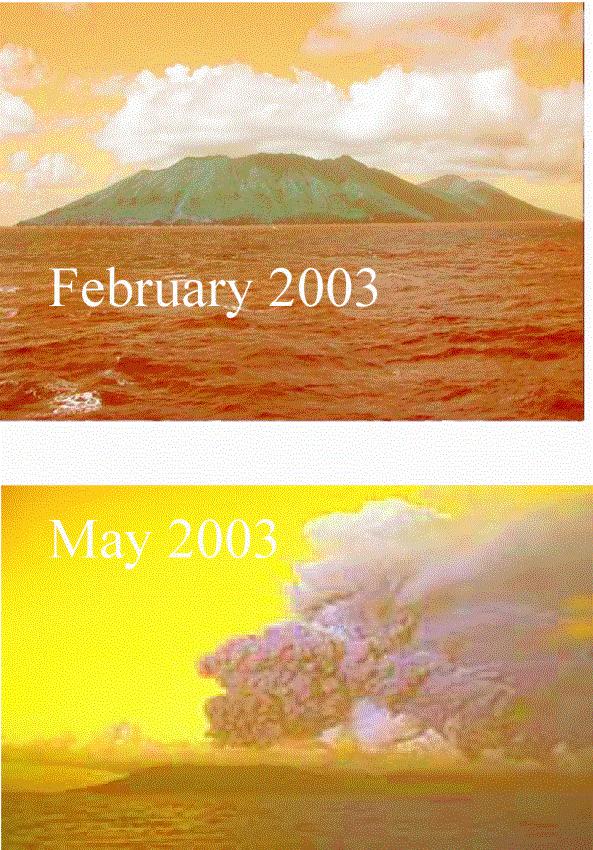
north of NeMO on the West Valley and Cobb Offset ridge segments. An array of autonomous hydrophones were deployed along the Marianas Islands as part of the Sound in the Sea and Ring of Fire expeditions sponsored by the NOAA Ocean Exploration Program. During the deployment, the hydrophones recorded the first historical eruption in 10,000+ years of the volcano comprising Anatahan Island. The hydrophones detected earthquake and volcanic tremor activity associated with the Anatahan eruption 1.5 hrs before the ash cloud was observed by satellite. Customer(s): This research is a unique and integral part of a national oceanographic research effort to discover and understand natural ocean variability which, through processes originating at the bottom of the ocean, affects the Earth's entire hydrosphere. This research also provides NOAA with the basis upon which to develop an informed perspective on natural variability of such ocean environmental regimes as biological nutrient and heat budgets and cycles. The program has direct, complementary links to efforts sponsored by the National Science Foundation and the research also provides a framework for implementation of research sponsored by the new NOAA Ocean Exploration program. In addition, all hydrophone data collected under the auspices of this research are made available to the ocean science community and the general public over the worldwide web at http://www.pmel.noaa.gov/vents/acoustics/seismicity/seismicity.html NOAA Program Matrix: Ecosystem Research Major Activity: Fisheries Oceanography Coordinated Investigations (FOCI) Objective: Monitor and observe ecosystem change in the Bering Sea and North Pacific Ocean leading to better prediction of fish stocks. NOAA Performance Measure: Increased area covered and number of ecological conditions monitored by state-of-the-art observations systems and platforms that provides necessary information for NOAA's stewardship responsibilities. OAR Performance Measure: Increased agreement between annual NMFS forcases of AK fisheries (especially pollock) and actual recruitment measurements. Baseline: 75% Agreement (9 year average). Target: 100% (2007).
Purpose: Predictive capabilities for North Pacific ecosystems and recovery efforts for Steller sea lions can be improved by considering the effect of climate change on the environment. To advance our knowledge of relationships between climate and ecosystem, it is necessary that we monitor regime or climate events in the important areas of Alaska coastal waters. El Niño is a documented and detectable oceanic climate signal. The Gulf of Alaska and Bering Sea respond to El Niño and may provide information about how these ecosystems will respond to other climate shifts. Shifts in climate impact ecosystems, including Steller sea lion populations. Efforts and Results (to date): During FY 2004, FOCI logged 186 days at sea on 17 cruises, investigating effects of climate- and shorter-scale forcing on marine ecosystems of the Gulf of Alaska and Bering Sea/Aleutian Islands, including the changing physical environment encountered by Steller sea lions. During this period, FOCI deployed ~50 satellite-tracked drifters and 68 oceanographic moorings, expanding geographic coverage and ecosystem variables measured. In addition, the program recovered 78 moorings, some of which were deployed the previous year. These moorings measured temperature, salinity, fluorescence, nutrients, currents and meteorological parameters on hourly intervals. Some information from recovered moorings indicates warmer bottom temperatures in the Gulf of Alaska and warmer water column temperatures on the Bering Sea shelf, all of which can be attributed to El Niño. We are in the process of resolving the more subtle signals in fluorescence and currents that are a response to El Niño. This was a relatively weak El Niño, and the Alaska ecosystem signal is also weak. Five manuscripts have been accepted for publication in FISHERIES OCEANOGRAPHY exploring the physical environment of the Aleutian Islands where Steller sea lion populations continue to decrease. In addition, program scientists are developing a manuscript comparing the response of Alaskan ecosystems during El Niño and non El Niño years utilizing the data collected from these moorings. Information collected also was incorporated into the annual FOCI recruitment forecast for the 2004-year class of walleye pollock in the Gulf. Customer(s): The ultimate customer for information stemming from these observations is the North Pacific Fishery Management Council. Results also are passed to NMFS stock assessors, other scientists studying the region and stakeholders. Mission Goal: Understanding Climate Variability and Change to Enhance Society's Ability to Plan and RespondNOAA Program Matrix: Climate Observatons and Analysis Major Activity: Integrated ocean observations Objective: Build and sustain a global climate observing system that will respond to the long-term observational requirements of the operational forecast centers, international research program, and major scientific assessments. NOAA Performance Measure: Increased number of long-term observations collected, archived, available, and accessible where random errors and time-dependent biases have been minimized and assessed. OAR Performance Measure: Determine the role of the ocean in decadal and multidecadal climate fluctuations and improve understanding of large-scale interactions between the ocean and atmosphere.
Purpose: As part of NOAA’s effort to build a sustained integrated ocean observing system, PMEL and AOML continue their efforts to collect, quality-control, archive, and distribute research-quality datasets in support of the NOAA Office of Climate Observations. These measurements serve both the research and operational user communities within and outside of NOAA. AOML and PMEL observation systems include TAO/PIRATA moored arrays, satellite-tracked surface drifters, ARGO floats, and a systematic 10-year reoccupation of historic meridional hydrographic sections to help quantify long-term oceanic change. Efforts and Results (to date): Long-term observing systems managed and/or conducted by PMEL and AOML include the following:
Customers: Datasets from these observing systems are available on the internet and serve both operational and research needs within and outside of NOAA, including national and international groups such as CLIVAR, Carbon programs, and the International Panel on Climate Change (IPCC). Users of the SST data from the drifters include NESDIS for satellite calibration, NCEP for initialization of seasonal to interannual forecasts, and the scientific community for increased understanding of the coupled global climate system. TAO, PIRATA, and Argo data are used by government and academic researchers and modelers to further our knowledge of climate processes and to improve climate forecasts. As with the drifter data, operational users from NCEP and international climate centers utilize these data in support of seasonal to interannual climate forecasts. NOAA Program Matrix: Climate Forcing Major Activity: Global carbon cycle Objective: Monitor and understand atmospheric trends in CO2 and oceanic and terrestrial emission and uptake processes to support policy decisions in carbon management to mitigate unwanted effects in climate change. NOAA Performance Measure: Reduced uncertainty in the estimation of the oceanic carbon sink. Decreased degree of uncertainty of climate system processes, including the role of the ocean in the radiative forcing of CO2 and in climate forecast products. OAR Performance Measure: Determine the change in the inventory of anthropogenic carbon dioxide in the North Atlantic (by 2007) and the North Pacific (by 2010) oceans over the previous decade to +/- 20%
Purpose: The measurement-based changes in the inventory of anthropogenic carbon in the ocean are a critical constraint for models and for our understanding of the role of the ocean in the sequestration of excess carbon dioxide from the atmosphere. Furthermore, information on decadal timescales is essential to determine any feedbacks of oceanic carbon sequestration due to climate change, and to determine the role of natural variability on the oceanic carbon system. Efforts and Results (to date): The first three cruises of the 19 NSF-NOAA joint CLIVAR/ CO2 Repeat Hydrography Program cruises were completed in 2003. For the FY 2003 effort, the program is focusing on the North Atlantic to provide a constraint for the North American Carbon Program. The initial program highlights are that the ventilation pattern/circulation in the North Atlantic thermocline has changed dramatically based on changes in temperature and oxygen content (Fig. 1). Also, we have been able to unambiguously determine an increase in total carbon content in the upper ocean over the last 6 to 10 years suggesting that uptake of anthropogenic CO2 continues unabated and that we can detect anthropogenic carbon increase in the ocean on decadal timescales (Fig. 2). The significant Dissolved Inorganic Carbon (DIC) increase of about 5 – 22 µmol kg-1 at intermediate depths from about 100 – 800m north of ~ 20°N reflect, in part, the rapid uptake and transport of anthropogenic CO2 . in the Mode Waters on the North Atlantic Ocean, which are formed each winter by cooling and convective mixing. A lack of strong wintertime mixing north of 20°N during the latter half of the decade of the 1990s (North Atlantic Oscillation positive phase) may have caused the anthropogenic CO2 to be trapped in this layer and retained there for periods as long as several years. Customer(s): Research collaborators in carbon cycle research throughout the world, including those specific to atmospheric, land, and coastal and open-ocean science. The CO2 data produced in this program will be used in the biogeochemical models will be used by the International Panel on Climate Change (IPCC), climate researchers, and by the climate impacts community to support decision processes. NOAA Program Matrix: Climate Forcing Major Activity: Field studies of global climate-related chemistry and transport processes in the lower troposphere. Objective: Carry out and analyze airborne and surface measurements of atmospheric species and transformation processes associated with the global transport and distribution of climate-related emissions. NOAA Performance Measure: Decreased degree of uncertainty of climate system processes, including radiative forcing, in climate forecast products. OAR Performance Measure: By 2006/7, reduce the uncertainty in the direct scattering and absorption of radiation by aerosols of North American Origins. Baseline: 2001 IPCC TAR. Target: 10-25% reduction in uncertainty.
Purpose: Atmospheric aerosol particles affect the Earth's radiative balance both directly by scattering and absorbing solar radiation and indirectly by modifying the optical properties and lifetime of clouds. Although aerosols have a potential climatic importance over and down wind of industrial regions that is equal to that of anthropogenic greenhouse gases, they are still poorly characterized in global climate models. This is a result of a lack of both globally distributed data and a clear understanding of the processes linking gaseous precursor emissions, atmospheric aerosol properties, and the spectra of aerosol optical depth and cloud reflectivity. At this time, tropospheric aerosols pose one of the largest uncertainties in model calculations of climate forcing [IPCC, 2001]. This uncertainty significantly limits our ability to assess the effect of natural and human induced changes in the chemistry of the atmosphere on global climate. Efforts and Results (to date): The New England Air Quality Study-Intercontinental Transport and Chemical Transformation (NEAQS-ITCT) 2004 field mission took place in July/August 2004. NOAA scientists conducted measurements of aerosol properties and distributions on the NOAA RV Ronald H. Brown, the NOAA WD-P3, a DC-3 and at a ground site in Nova Scotia. Aerosol radiation experiments during the campaign were coordinated with Ronald H. Brown, two NASA aircraft, and Terra satellite overpasses. The project data are now being analyzed. A series of data workshops and meeting presentations is planned for 2005. Customer(s): The data sets collected during the campaign
are being used to evaluate numerical models that extrapolate aerosol properties
and processes from local to regional scales and to assess the regional
direct and indirect radiative forcing by aerosols. |
About us | Research | Publications | Data | Theme pages | Infrastructure |
| US Department of Commerce | NOAA | OAR | PMEL Pacific Marine Environmental Laboratory NOAA /R/PMEL 7600 Sand Point Way NE Seattle, WA 98115 |
Phone: (206) 526-6239 Fax: (206) 526-6815 Contacts Privacy Policy | Disclaimer | Accessibility Statement | oar.pmel.webmaster@noaa.gov |
|