|
||
Where on Earth...? MISR Mystery Image Quiz #8
| ||||
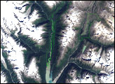
Here’s another chance to play geographical detective! This Multi-angle Imaging SpectroRadiometer (MISR) image covers an area measuring approximately 297 kilometers x 221 kilometers, and was captured by the instrument’s vertical-viewing (nadir) camera on April 12, 2001. A large river flows from the left side of the image, below center, and traverses the image, angling northeast toward the upper right. It then makes a hairpin turn and continues to flow in a generally southward direction near the right-hand side of the image. Below are eight statements about this river, only some of which are true. Use any reference materials you like, and mark each statement true or false:
Quiz Rules
Answers will be published on the MISR web site (http://www-misr.jpl.nasa.gov/) in conjunction with the next weekly image release. The names and home towns of respondents who answer all questions correctly by the deadline will also be published in the order responses were received. The first 3 people on this list who are not affiliated with NASA, JPL, or MISR and who did not win a prize in the last quiz will be sent a print of the image. A new “Where on Earth...?” mystery appears as the MISR “image of the week” approximately once per month. A new image of the week is released every Wednesday at noon Pacific time on the MISR home page. The image also appears on the Atmospheric Sciences Data Center home page, though usually with a several-hour delay. Image courtesy NASA/GSFC/LaRC/JPL, MISR Team. Recommend this Image to a Friend Back to: Newsroom
Also see |
View Images Index
| |||
|
Subscribe to the Earth Observatory About the Earth Observatory Contact Us Privacy Policy and Important Notices Responsible NASA Official: Lorraine A. Remer Webmaster: Goran Halusa We're a part of the Science Mission Directorate |
 Click here to view full image