|
||
Luquillo Mountains, Puerto Rico
| ||||
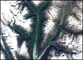
The Luquillo Mountains are located in the northeastern portion of Puerto Rico, and they rise to elevations of 1,075 meters (about 3,527 feet). The mountains are mainly made up of volcanic rock that was uplifted by tectonic activity between approximately 37–28 million years ago. (Puerto Rico is located between the junction of the North American and Caribbean tectonic plates.) Prevailing easterly winds bring moisture from the Caribbean Sea, which becomes precipitation as the winds cross the mountains. Higher elevations receive more rainfall than lower elevations, leading to subtropical forest types in the lowlands and high-mountain forest types near the summits. This astronaut photograph, taken during the rainy season, illustrates the rich vegetation on the mountains. The rapid transition between ecosystems based on elevation, along with land use history and exposure to frequent natural disturbances such as hurricanes, makes the Luquillo Mountains an ideal location for ecological study. The Luquillo Experimental Forest Long-Term Ecological Research (LTER) site is contained within the Luquillo National Forest, covering much of the mountains to the southwest of the city of Luquillo (lower left). Past human activities, including logging, agriculture, charcoal production, and coffee plantations, have determined much of the current ecosystem structure. Results of research at Luquillo Forest indicate that the island’s forest ecosystems recover more rapidly from natural disturbances (like hurricanes) than they do from human disturbance. Astronaut photograph ISS016-E-18385 was acquired on December 23, 2007, with a Kodak 760C digital camera fitted with a 400 mm lens, and is provided by the ISS Crew Earth Observations experiment. The image was taken by the Expedition 16 crew, and is provided by the Image Science & Analysis Laboratory, Johnson Space Center. The image in this article has been cropped and enhanced to improve contrast. Lens artifacts have been removed. The International Space Station Program supports the laboratory to help astronauts take pictures of Earth that will be of the greatest value to scientists and the public, and to make those images freely available on the Internet. Additional images taken by astronauts and cosmonauts can be viewed at the NASA/JSC Gateway to Astronaut Photography of Earth. Caption by William L. Stefanov, NASA-JSC. Recommend this Image to a Friend Back to: Newsroom
Also see |
View Images Index
| |||
|
Subscribe to the Earth Observatory About the Earth Observatory Contact Us Privacy Policy and Important Notices Responsible NASA Official: Lorraine A. Remer Webmaster: Goran Halusa We're a part of the Science Mission Directorate |
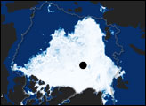
 Click here to view full image