|
||
Messina Strait, Italy
| ||||
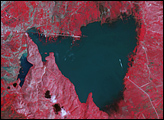
Between the island of Sicily and mainland Italy runs a narrow strip of water, the Messina Strait. Connecting the Tyrrhenian Sea in the west with the Ionian Sea in the east, this skinny strip of water is just 3 kilometers (2 miles) wide at its narrowest point. The 32-kilometer- (20-mile-) long strait widens toward the south, but doesn’t grow very deep, only about 90 meters (300 feet). Yet for such a narrow, shallow water body, it has long posed problems for sailors. The Strait’s treacherous conditions may have been the location that inspired the Greek myth of Scylla and Charybdis, two sea monsters that plagued Odysseus and his crew on their journey. Even today, the Messina Strait’s strong currents can rip seaweed from the ocean floor. The main current runs from south to north, but a smaller current runs in the opposite direction. The currents alternate about every six hours, and the strait’s complicated wave patters can be seen from space. On August 11, 2003, the Advanced Spaceborne Thermal Emission and Reflection Radiometer (ASTER) on NASA’s Terra satellite took this picture of the Messina Strait. When this picture was taken, the Sun was at just the right angle to illuminate two sets of waves. The more obvious set appears as a series of concentric rings pushing toward the south. Perpendicular to the strong waves are shallower waves that give the water a rough appearance. On either side of the strait, the land surface appears rugged but lush, with bright green vegetation covering most of the land surface. The sprawling purple splotch near Sicily’s coast is Mount Etna, which acts up periodically. In this image, however, the volcano is subdued, with lazy white clouds floating overhead. NASA image created by Jesse Allen, using data provided courtesy of the NASA/GSFC/MITI/ERSDAC/JAROS, and U.S./Japan ASTER Science Team. Recommend this Image to a Friend Back to: Newsroom
Also see |
View Images Index
| |||
|
Subscribe to the Earth Observatory About the Earth Observatory Contact Us Privacy Policy and Important Notices Responsible NASA Official: Lorraine A. Remer Webmaster: Goran Halusa We're a part of the Science Mission Directorate |
 Click here to view full image