
|
||
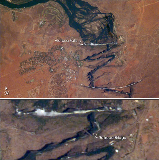
Victoria Falls, Zambezi River
| |||
high resolution 1000 pixel-wide image (920 kB JPEG) Victoria Falls is one of the most famous tourist sites in subsaharan Africa. Details of the Falls are visible in this image taken with the 800 mm lens by Astronaut Edward Lu from the Space Station on September 4, 2003. A major river in south-central Africa, the Zambezi River flows from western Zambia to the Indian Ocean in Mozambique. In the sector imaged here, it flows southeast (top left to bottom right) in a wide bed before plunging suddenly 130 meters over the Victoria Falls into a narrow gorge. The falls and their famous spray clouds are 1700 m long, the longest sheet of falling water in the world. The falls appear as a ragged white line. The small town of Victoria Falls in Zimbabwe appears just west (left) of the falls, with smaller tourist facilities on the east bank in Zambia. The international railroad bridge over the second gorge (between Zimbabwe and Zambia) can be seen in the detailed view on the bottom (arrow). The positions of the falls are controlled by linear fault lines in the underlying basalt rocks. The falls have moved upstream (bottom to top) by intense river erosion, elongating the zig-zag gorge in the process. Prior positions of the strongly linear falls can be detected. The earliest on this cropped view may have been the longest (dashed line). The zig-zags represent subsequent positions, all with the characteristic water-worn lip on the upstream side. The falls will continue to erode northward. Astronaut photograph ISS007-E-14361 was taken September 4, 2003 with a Kodak DCS760 digital camera equipped with an 800mm lens and provided by M. Justin Wilkinson (Lockheed Martin / Earth Observations Laboratory, Johnson Space Center). The International Space Station Program supports the laboratory to help astronauts take pictures of Earth that will be of the greatest value to scientists and the public, and to make those images freely available on the Internet. Additional images taken by astronauts and cosmonauts can be viewed at the NASA/JSC Gateway to Astronaut Photography of Earth. Recommend this Image to a Friend Back to: Newsroom
Also see |
View Images Index
| ||
|
Subscribe to the Earth Observatory About the Earth Observatory Contact Us Privacy Policy and Important Notices Responsible NASA Official: Lorraine A. Remer Webmaster: Goran Halusa We're a part of the Science Mission Directorate |
