
|
||
Egypt’s Great Pyramids of Giza
| |||
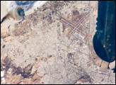
high resolution 1000 pixel-wide image (650 kB JPEG) All astronauts are interested in observing unique human footprints from space, and especially those reflecting thousands of years of human activities. The region of the Great Pyramids of Giza—the last remaining wonder of the Seven Wonders of the Ancient World—is a favorite target. Although the pyramids have been imaged many times before by astronauts (for example: Space Station View of the Pyramids at Giza) , each new image provides a unique look at the archeological monument, depending on the viewing angle from the ISS and the illumination from the sun. Giza is a royal burial place, commissioned and built by pharaohs during the fourth dynasty around 2550 BC. Started by Khufu, continued by his son Khafre (Khafre pyramid and the Sphinx), and later by his son, Menkaure, the complex also includes many tombs and temples for queens, other members of royal families, and royal attendants. The low sun angle in this image allows for many of the smaller surrounding monuments to be observed. Further, the sides of the pyramid align with the cardinal directions. In this view, the shadows from afternoon sun provide directional arrows that point east. For scale, the current length of the large pyramid at the base is 227 m (745 ft), and the height is 137 m (449). Today, Giza is a rapidly growing region of Cairo. Population growth in Egypt continues to soar, leading to new construction. New roads for large new developments are obvious in the desert hills northwest and southwest of the pyramids. Documenting patterns of urban growth around the world is a prime science objective for Earth photography by ISS astronauts. Astronaut photograph ISS007-E-12915 was taken August 18, 2003 with a Kodak DCS760 digital camera equipped with an 800mm lens and provided by Cynthia A. Evans (Lockheed Martin / Earth Observations Laboratory, Johnson Space Center). The International Space Station Program supports the laboratory to help astronauts take pictures of Earth that will be of the greatest value to scientists and the public, and to make those images freely available on the Internet. Additional images taken by astronauts and cosmonauts can be viewed at the NASA/JSC Gateway to Astronaut Photography of Earth. Recommend this Image to a Friend Back to: Newsroom
Also see |
View Images Index
| ||
|
Subscribe to the Earth Observatory About the Earth Observatory Contact Us Privacy Policy and Important Notices Responsible NASA Official: Lorraine A. Remer Webmaster: Goran Halusa We're a part of the Science Mission Directorate |


