|
||
TOMS Shows Dust Plume Over Western Africa
| |||
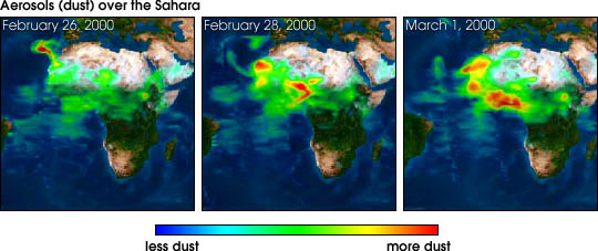
This series of images shows a dust plume obtained from Total Ozone Mapping Spectrometer (TOMS) data over the Sahara Desert and extending over the Atlantic Ocean and Canary Islands. The land sources of the dust plume are clearly visible, with the main source coming from Western Sahara and Mauritania. The green to red false colors in the dust plume image represent increasing amounts of aerosol, with the densest portion over the ocean. Under the densest portions of the dust plume (red) the amount of ultraviolet sunlight is reduced to half its normal value. Between February 27 to February 29 the ocean dust plume decreases while a massive dust plume develops over the land that covers a region from the equator to 30° N latitude. Based on previous dust events observed by TOMS, there should be another dense plume over the ocean during the next few days. For more information see the TOMS Home Page
Image courtesy TOMS project Recommend this Image to a Friend Back to: Newsroom
Also see |
View Images Index
| ||
|
Subscribe to the Earth Observatory About the Earth Observatory Contact Us Privacy Policy and Important Notices Responsible NASA Official: Lorraine A. Remer Webmaster: Goran Halusa We're a part of the Science Mission Directorate |