|
||
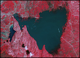
Yellowknife, Canada
| ||||
Extensive wetlands lie near the town of Yellowknife, near the Great Slave Lake in northern Canada. The shallow lakes seen in this image have formed in grooves in the landscape that were carved by glaciers during the last Ice Age. This image was acquired by Landsat 7's Enhanced Thematic Mapper plus (ETM+) sensor on March 7, 2001. This is a false-color composite image made using shortwave infrared, infrared, and red wavelengths.
Image provided by the USGS EROS Data Center Satellite Systems Branch. This image is part of the ongoing Landsat Earth as Art series.
Recommend this Image to a Friend Back to: Newsroom
Also see |
View Images Index
| |||
|
Subscribe to the Earth Observatory About the Earth Observatory Contact Us Privacy Policy and Important Notices Responsible NASA Official: Lorraine A. Remer Webmaster: Goran Halusa We're a part of the Science Mission Directorate |
 Click here to view full image