|
||
Where on Earth...? MISR Mystery Image Quiz #11
| ||||
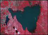
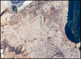
Here’s another chance to play geographical detective! These images from the Multi-angle Imaging SpectroRadiometer (MISR) were captured by the instrument’s nadir camera on November 19, 2001, and show a natural-color (left) and false-color (right) view of a 157 kilometer x 210 kilometer area. The natural-color image is composed of data from the camera’s red, green, and blue bands. In the false-color view, the green channel has been replaced with data from the camera’s near-infrared band. This emphasizes the appearance of vegetation. North is toward the top. Use any reference materials you like to answer the following 5 questions:
Quiz Rules
Answers will be published on the MISR web site (http://www-misr.jpl.nasa.gov) in conjunction with the next weekly image release. The names and home towns of respondents who answer all questions correctly by the deadline will also be published in the order responses were received. The first 3 people on this list who are not affiliated with NASA, JPL, or MISR and who did not win a prize in the last quiz will be sent a print of the image. A new "Where on Earth...?" mystery appears as the MISR "image of the week" approximately once every two months. A new image of the week is released every Wednesday at noon Pacific time on the MISR home page. Image courtesy NASA/GSFC/LaRC/JPL, MISR Team. Recommend this Image to a Friend Back to: Newsroom
Also see |
View Images Index
| |||
|
Subscribe to the Earth Observatory About the Earth Observatory Contact Us Privacy Policy and Important Notices Responsible NASA Official: Lorraine A. Remer Webmaster: Goran Halusa We're a part of the Science Mission Directorate |
 Click here to view full image