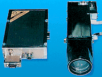
Clementine Laser Image Detection and Ranging (LIDAR) System
NSSDC ID: 1994-004A-04
Mission Name: Clementine
Principal Investigator: Dr. Eugene M. Shoemaker
Description
The Clementine Laser Image Detection And Ranging (LIDAR) experiment was designed to measure the distance from the spacecraft to a point on the surface of the Moon. This will allow an altimetric map to be made, which can be used to constrain the morphology of large basins and other lunar features, study stress and strain and flexural properties of the lithosphere, and can be combined with gravity to study the density distribution in the crust. The experiment was also designed to measure distances to the surface of Geographos, but this phase of the mission was cancelled due to a malfunction.
The LIDAR ranging system consisted of a 180 mJ, 1064 nm wavelength Nd-YAG (Yttrium-Aluminum-Garnet) laser transmitter which transmitted pulses to the lunar surface. The laser produced a pulse with a width less than 10 ns. At 1064 nm wavelength, the pulse had an energy of 171 mJ with a divergence less than 500 microrad. At 532 nm, it had a 9 mJ pulse with a 4 millirad divergence. The reflected pulse travelled through the High-Resolution Camera telescope, where it was split off by a dichroic filter to a silicon avalanche photodiode detector. The detector was a single 0.5 x 0.5 mm cell SiAPD receiver with a field of view of 0.057 square degrees. The laser had a mass of 1250 g, the receiver was housed in the 1120 g HIRES camera. The travel time of a pulse gave the range to the surface. The LIDAR memory could save up to six return detections per laser firing, with a threshold set for the best compromise between missed detections and false alarms. The returns were stored in 39.972 m range bins, equal to the resolution of the 14-bit clock counter. The LIDAR has a nominal range of 500 km, but altimetric data was gathered for altitudes up to 640 km, which allowed coverage from 60 degrees south to 60 degrees north by the end of the lunar phase of the mission. The vertical resolution is 40 m, and the horizontal spot resolution is about 100 m. The across track spacing of the measurements at the equator was about 40 km. One measurement was made each second over a 45 minute period during each orbit, giving an along track spacing of 1--2 km.
Facts in Brief
Mass: 2.37 kg
Power (avg): 6.8 W
Bit rate (avg): 1630.0 bps
Funding Agencies
- Department of Defense-Department of the Navy (United States)
- NASA-Office of Space Science (United States)
Disciplines
- Planetary Science: Geology and Geophysics
- Planetary Science: Small Bodies
Additional Information
Questions or comments about this experiment can be directed to:
Selected References
Smith, D. E., et al., Topography of the Moon from the Clementine lidar, J. Geophys. Res., 101, No. E1, 1591-1611, Jan. 1997.
Clementine Gravity and Topography Data
