
|
||
|
|
||
 Mapping Earth's Diverse Landscapes
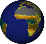
Nearly every aspect of our lives is tied into the vegetation and ground cover that surround us. Farms feed us, forests provide us with oxygen and building materials, rivers and lakes yield fresh water to drink, and cities shelter us. When land covers change, our health, economy, and environment can all be affected. Twenty-five years ago, for instance, thousands of people starved when the vegetation in the Sahel region of Africa dried up during an extended drought. In 1993, small town after small town had to be evacuated as the Mississippi River overflowed its banks and covered an area the size of Iowa in two feet of water. For years scientists across the world have been mapping these changes in the landscape to prevent future disasters, monitor natural resources, and collect information on the environment. While land cover can be observed on the ground or by airplane, the most efficient way to map it is from space. By using such imaging satellites as Landsat 5, Landsat 7 and Terra, scientists have the ability to observe large tracts of the Earth's surface in a fraction of the time needed to complete aerial or ground surveys. The data beamed back to Earth from these satellites can also be manipulated to highlight where one type of land cover begins and another ends. next: Mapping Earth's Diverse Landscapes The image at top shows landcover over one hemisphere, based on data from the University of Maryland Laboratory for Global Remote Sensing Studies Global Land Cover Project. Click the image to view the data in 3D and see a pallette that describes the landcover types. |
 Land Cover Classification Related Data Sets: Related Case Studies:
|
|
Subscribe to the Earth Observatory About the Earth Observatory Contact Us Privacy Policy and Important Notices Responsible NASA Official: Lorraine A. Remer Webmaster: Goran Halusa We're a part of the Science Mission Directorate |
|
|