|
Mission
|
MODIS Image of the Day
|
|
The MODIS Rapid Response System was developed to provide daily satellite images of the Earth's landmasses in near real time. True-color, photo-like imagery and false-color imagery are available within a few hours of being collected, making the system a valuable resource for organizations like the U.S. Forest Service and the international fire monitoring community, who use the images to track fires; the United States Department of Agriculture Foreign Agricultural Service, who monitors crops and growing conditions; and the United States Environmental Protection Agency and the United States Air Force Weather Agency, who track dust and ash in the atmosphere. The science community also uses the system in projects like the Aerosol Robotic Network (AERONET), which studies particles like smoke, pollution, or dust in the atmosphere. More information about science and application partners, including links, is provided on our applications page. Captioned interpreted images for educators, the media, and the public are available through the Earth Observatory. The system is freely available everyone--scientists, operational users, educators, and the general public.
The Moderate Resolution Imaging Spectroradiometer (MODIS) flies onboard NASA's Aqua and Terra satellites
as part of the NASA-centered international Earth Observing System. Both satellites orbit the Earth from pole to pole, seeing most of the globe every day. Onboard Terra, MODIS sees the Earth during the morning, while Aqua MODIS orbits the Earth in the afternoon.
|
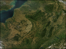
: Clear Skies Over Western Europe
|
|
News
|
Quick links
|
|
Effective 20 May 2008:
Signicant changes were made in the production and distribution of subset imagery. Please see our subset main page for more details.
PLEASE NOTE:
In order to expand our geographic coverage of GIS compatible imagery ("Subsets") to cover all land and coastal areas, within the constraints of our current hardware resources, we are reducing some of the imagery that we have historically provided on our website.
Effective 11 January 2008:
All 250-meter, near-real-time swath images acquired before August 6, 2007, were removed from the system on January 11, 2008. Thanks to the temporary loan of equipment from a colleague, we had been able to maintain the archived 250-meter images past the October 1 deadline previously announced. However, we now have to remove the images. We will maintain a short-term archive of these images for at least 30 days or longer, if disk space permits. The 4-km, 2-km, 1-km, and 500-meter images will still be available for the full Rapid Response archive, and the 250-meter data may be ordered through LAADS as usual.
We thank you for your understanding. If you have any questions or concerns about these changes please contact our Outreach Coordinator.
|
+ Near-real-time production
+ Near-real-time subsets
+ Image Gallery
+ About us
+ Related sites
+ Frequently Asked Questions
+ Production status
+ Products
+ Web Fire Mapper
+ USFS Active Fire Maps
|
|
Web Fire Mapper
|
Active Fire Maps
|
Near-real-time Subsets
|
![[ Web Fire Mapper image ]](https://webarchive.library.unt.edu/eot2008/20080917104741im_/http://rapidfire.sci.gsfc.nasa.gov/images/webfiremapper.jpg)
The Web Fire Mapper at the University of Maryland provides access to current and archived fire locations detected by the MODIS Rapid Response System through an interactive ArcIMS interface with an extensive database of region-specific layers and ancillary information.
+ Read more and access data
|
![[ USFS ArcIMS image ]](https://webarchive.library.unt.edu/eot2008/20080917104741im_/http://rapidfire.sci.gsfc.nasa.gov/images/USFS_ArcIMS.jpg)
The USFS's Remote Sensing Applications Center generates regional maps for the US fire managers using the active fire locations provided by the MODIS Rapid Response System, and also makes them available through an interactive ArcIMS interface over the conterminous United States, Alaska, and Canada.
+ Read more and access data
|
![[ Subset map ]](https://webarchive.library.unt.edu/eot2008/20080917104741im_/http://rapidfire.sci.gsfc.nasa.gov/images/subsetmap.jpg)
A large number of near-real-time georectified images across the world are available in our MODIS Rapid Response Subsets page in GIS-compatible format, including most AERONET sunphotometer sites.
+ Read more and download imagery
|
|
Natural Hazards
|
Applications
|
Global Fire Maps
|
![[ Hurricane example image ]](https://webarchive.library.unt.edu/eot2008/20080917104741im_/http://rapidfire.sci.gsfc.nasa.gov/images/nathaz.jpg)
A large collection of MODIS Rapid response imagery can be found in the Earth Observatory's Natural Hazards section, with captions that provide pertinent information about each image.
+ Read more
|
![[ Applications summary image ]](https://webarchive.library.unt.edu/eot2008/20080917104741im_/http://rapidfire.sci.gsfc.nasa.gov/images/applications.jpg)
The MODIS Rapid Response imagery is used in a number of applications, including fire monitoring, burn area mapping, crop monitoring, flood mapping, and air quality monitoring.
+ Read more
|
![[ Fire Map image ]](https://webarchive.library.unt.edu/eot2008/20080917104741im_/http://rapidfire.sci.gsfc.nasa.gov/images/firemap.jpg)
Global 10-day fire maps are generated using the MODIS Rapid Response fire locations to represent the current fire activity across the world.
+ Read more
|
|