
State & Local Info
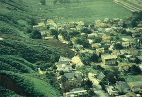
Image of the 1995 La Conchita landslide, near Ventura, California. This seaside community suffered a re-activation of the landslide in 2005, which killed 10 people. For a film of the 2nd landslide and more information on southern California landslides, please see: our La Conchita event page
Local Information
Local Information is often the best source for detailed maps and information on landslides in a specific area. State Geological Surveys, city and county governments, and professional consultants have specific information that may be available for public use.
Landslide Emergency Management
Each locality usually has a unique protocol and procedure for landslide advisories, warnings, and potential evacuation. Most cities and counties have information on their home websites or have departments of emergency management which can be contacted by phone.
Mitigation
Mitigation includes any activities that prevent an emergency, reduce the chance of an emergency happening, or lessen the damaging effects of unavoidable emergencies. Investing in preventive mitigation steps now such as planting ground cover (low growing plants) on slopes, or installing flexible pipe fitting to avoid gas or water leaks, will help reduce the impact of landslides and mudflows in the future. For more information on mitigation, contact your local emergency management office.
