
 Feeds & Data
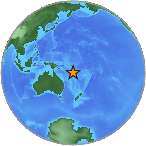
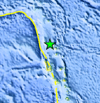
Magnitude 6.9 - VANUATU
2008 September 08 18:52:08 UTC
Earthquake Details
| Magnitude | 6.9 |
|---|---|
| Date-Time |
|
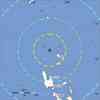
| Location | 13.514°S, 166.967°E |
| Depth | 121.8 km (75.7 miles) set by location program |
| Region | VANUATU |
| Distances | 225 km (140 miles) N of Luganville, Espiritu Santo, Vanuatu 335 km (205 miles) SSE of Lata, Santa Cruz Islands, Solomon Isl. 490 km (305 miles) NNW of PORT-VILA, Efate, Vanuatu 2115 km (1320 miles) NE of BRISBANE, Queensland, Australia |
| Location Uncertainty | horizontal +/- 3.7 km (2.3 miles); depth fixed by location program |
| Parameters | NST=326, Nph=326, Dmin=889 km, Rmss=0.76 sec, Gp= 25°, M-type=regional moment magnitude (Mw), Version=V |
| Source |
|
| Event ID | us2008wsbh |
- This event has been reviewed by a seismologist.
- Did you feel it? Report shaking and damage at your location. You can also view a map displaying accumulated data from your report and others.
Earthquake Summary
 Tsunami Information
- NOAA West Coast & Alaska Tsunami Warning Center
- NOAA Pacific Tsunami Warning Center
- Tsunami Information Links
The earthquake locations and magnitudes cited in these NOAA tsunami bulletins are very preliminary and may be superceded by USGS locations and magnitudes computed using more extensive data sets.
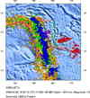
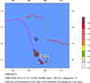
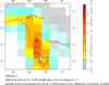
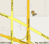
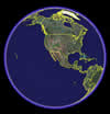
Earthquake Maps
Scientific & Technical Information

- Preliminary Earthquake Report
- U.S. Geological Survey, National Earthquake Information Center:
World Data Center for Seismology, Denver
