OVERVIEW
|
 |
|
The Tropical Rainfall Measuring Mission (TRMM) is a joint mission between NASA and the Japan Aerospace Exploration Agency (JAXA) designed to monitor and study tropical rainfall.
Basic Information
Launch Date |
November 27, 1997 |
Orbit |
Circular, non-sun-synchronous, with an inclination of 35 degrees to the Equator. |
Orbit Altitude |
350 km (1997/11/27 - 2001/08/08)
403 km (2001/08/24 - present) |
Altitude Change |
During the period of 2001/8/7 to 2001/8/14, the average operating altitude changed from 350 km to 403 km (referred to also as TRMM Boost). |
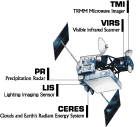
Instruments
Below are overview descriptions of the instruments on the TRMM satellite:
Visible Infrared Radiometer (VIRS) |
The VIRS (of NOAA AVHRR heritage) is a five-channel, cross-track scanning radiometer operating at 0.63, 1.6, 3.75, 10.8, and 12 um, which provides high resolution observations on cloud coverage, cloud type, and cloud top temperatures. |
TRMM Microwave Imager (TMI) |
The TMI (of DMSP SSM/I heritage) is a multichannel passive microwave radiometer operating at five frequencies: 10.65, 19.35, 37.0, and 85.5 GHz at dual polarization and 22.235 GHz at single polarization. The TMI provides information on the integrated column precipitation content, cloud liquid water, cloud ice, rain intensity, and rainfall types (e.g., stratiform or convective). |
Precipitation Radar (PR) |
The PR, the first of its kind in space, is an electronically scanning radar, operating at 13.8 GHz that measures the 3-D rainfall distribution over both land and ocean, and define the layer depth of the precipitation. |
Further information on these instruments may be found on the TRMM Instruments Web page.
|
|
|
|
|
FEATURED ITEMS
|
|
|
|
|
|
| |
TRMM Data Available Online
We have many TRMM products available for download via FTP. You can search TRMM products by time range, spatial area, and parameter.
+
Search Now
|
|
|
|
