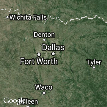
Hit-or-miss storms added almost 5 feet of water to Hood County’s Lake Granbury over the last few days but left lakes to the north and east that supply water to much of the Dallas region unchanged.
“There were sites with 4-, 5- and 6-inch amounts of rain” in Hood and Johnson counties, said Jesse Moore, a meteorologist with the National Weather Service in Fort Worth, with a site southeast of Granbury picking up 8.17 inches of rain and another just north of town getting 7.58 inches.
The Red Cross said Monday that nine homes in Hood County were left uninhabitable, though its assessment of the damage was not complete.
“But most areas across the region got anywhere from a half to an inch-and-a-half,” Moore said. “We just saw much heavier amounts to the west and southwest.”
So while Lake Granbury jumped from 49 percent of capacity on Saturday to almost 66 percent on Monday, Lavon Lake, the primary reservoir for 1.6 million people living north and east of Dallas, was slightly lower — 50.6 percent of capacity on Saturday and 50.5 on Monday.
Lavon serves the North Texas Municipal Water District, which has been hit hard by the ongoing drought.
Widespread rains Sunday and Monday mostly missed the lake and the creeks that feed it with rainwater. While Frisco and Celina, both west of the lake, reported more than an inch of rainfall, nearby McKinney saw only 0.08 inches.
Monday’s storms moved swiftly across the region from northwest to southeast, with gusty winds ahead of the storm but only modest amounts of rain.
The rains held morning temperatures in the mid- to upper-60s, with the afternoon warming only to the upper 80s, about 5 degrees below normal.
The front that blew through the area early Monday knocked out power to about 10,000 customers over a broad swath of North Texas, said Justin Ozuna, a spokesman for Oncor, the region’s electric provider.
“That’s down to about 2,100 now,” he said late Monday afternoon, “and we’ll continue working until all power is restored.”
The current weather pattern could steer more storms across the region over the next day or two. Rain chances decrease toward the end of the week, Moore said, though North Texas could see afternoon and evening thunderstorms Friday and Saturday.
Still, the heavy rains west of Dallas-Fort Worth were “a big bonus” for the drought-stricken Brazos region, Moore said.
“It was a slow-moving disturbance, with gulf moisture from the south and some tropical moisture from the Pacific in the upper levels,” he said. “That really helped enhance the rainfall totals.”
The Associated Press contributed to this report.
Follow Michael E. Young on Twitter @mikeyoungDMN.


