Seismic Risk at the Pebble Mine
Background
Mines operate on a scale of decades, but mine waste stays on-site forever. Tailings – a toxic solid-water slurry waste – are stored behind dams that must remain stable for centuries, through recurring earthquakes. Seismic mapping in the Pebble mine region is incomplete; actual fault locations are unknown. The Pebble Limited Partnership (PLP) must either determine fault locations or assume a worst case scenario: that a major fault runs directly under the mine. Preliminary earthquake mitigation plans for Pebble do not consider recent scientific information on fault locations, although damage to PLP’s tailings dams could release toxic mine waste into important salmon producing rivers.
Earthquakes in Alaska
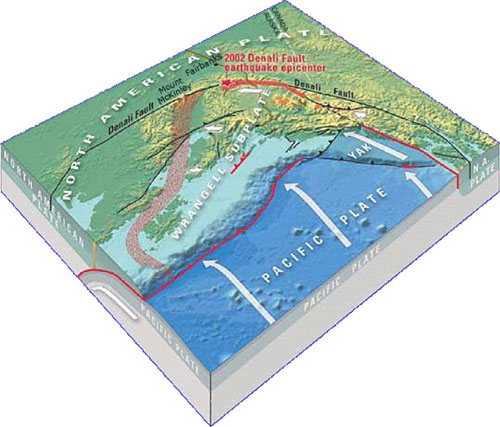
Alaska experiences magnitude 6-7 earthquakes at least 5 times a year and a magnitude 8 about every 13 years; most activity is from the North American plate colliding with the Pacific Plate (Figure 1). This seismic source region, termed the Alaska-Aleutian megathrust, is located ~125 miles from Pebble and has caused some of the world’s largest earthquakes, including the 1964 Prince William Sound 9.2 earthquake. Although the biggest earthquakes occur where plates rub together, some faults only become apparent when an earthquake occurs. The 7.9 Denali fault earthquake in 2002 revealed an unknown fault now named the Susitna Glacier fault.
 |
|---|
 |
|---|
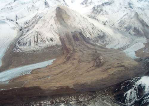
Earthquakes can cause impacts far from their source. For example, the Denali quake ruptured surfaces over 200 miles, triggered thousands of landslides (Figure 2), caused 22 foot wide rifts, damaged an airport 40 miles away and caused shocks 2,000 miles away. Tectonic processes that caused this quake also affect the Castle Mountain-Lake Clark fault system near Pebble mine.
Faults Near Pebble
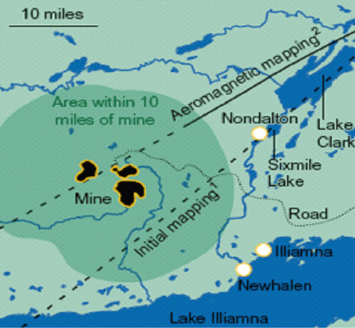
The Castle Mountain fault has one fork near Lake Clark (Figure 3). It is part of a fault field in Cook Inlet, where earthquakes of 4.6 to 5.7 occurred and where a magnitude 7 or greater can occur. The location of the Lake Clark fault relative to Pebble is unknown. Two USGS publications differ in where they map the fault, but both suggest it may run within 5 miles of Pebble, yet PLP claims the fault is 18 miles away (Figures 3 and 4).
 |
|---|
|
|---|
Earthquake Hazard
The Castle Mountain fault can experience a major earthquake. Earthquake effects on tailings dams at Pebble depend on their proximity to the fault. The PLP assumes the fault is ~18 miles from Pebble, and structures are currently designed to withstand a 7.8 earthquake originating at this location. However, if the fault runs 5 miles from the mine, the force can be three times greater for the same earthquake. Risks associated with earthquakes include:
- Tailings dam failure during shaking
- Landslides that can cause dams failure
- Landslides that can deposit material within the dam, causing tailings overflow
- Subsidence near underground mine workings, allowing water to enter and potentially release acid mine drainage
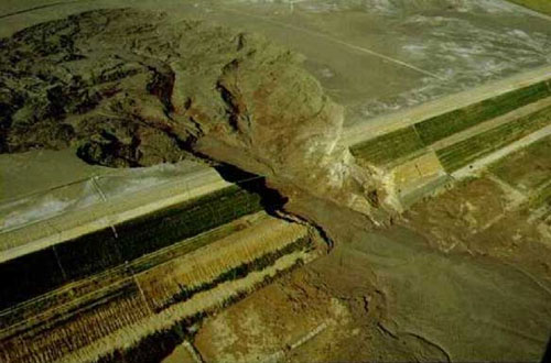
Proposed tailings dams at the Pebble Mine are 740 feet and 450 feet high, some of the largest in the world. In contrast, dams at Fort Knox and Red Dog are 330 feet and 177 feet high, respectively, and are not in seismically active areas. Dam or other mine facilities failure at Pebble mine could cause toxic waste to enter salmon streams and lakes surrounding the mine.
Conclusion
If mine structures are built to withstand a large earthquake on a fault 18 miles away, when in fact the fault lies closer, the shaking forces experienced by mine structures will be much greater than planned for. Because some mine facilities, including tailings dams, must last forever, regulatory agencies should require that the most conservative assumptions be used in mine designs. To date the earthquake analysis and predictions by PLP do not meet these criteria.
|
|---|
This summary was adapted from a paper by Bretwood Higman, Ph.D., March 2008. Paper and references available at http://www.groundtruthtrekking.org/PebbleHazardLetter.pdf.
Further Reading
Historical United States EarthquakesAlaska Seismic Hazard Safety Commission - Alaska Earthquake Statistics
Local Amplicafication of Seismic Waves from the MW7.9 Alaska Earthquake and Damaging Water Waves in Lake Union, Seattle, Washington


 Ask the EPA to protect Bristol Bay from mine waste! Send a letter to urge EPA to protect the world's greatest remaining salmon fishery!