


Visiting the Covered Bridges of Chester County, Part 1: The Northern Tier
Despite sitting close to downtown Philadelphia, Chester County is surprisingly pastoral. This fact, combined with its status as one of the original counties of Pennsylvania, gives is a significant number of historical covered bridges. In fact, 15 different covered bridges still dot the landscape of the county. This gives Chester County the fourth highest number of covered bridges in the state, behind only Lancaster, Washington, and Columbia Counties.
During my recent travels to Chester County, I had the chance to check out a handful of these bridges for myself. Since writing about 15 bridges at one time would be a bit extreme, I’m going to break down the covered bridges of Chester County into three separate articles, eventually showcasing every bridge that still stands in the county.
For this article, I’m going to be writing about the five most northerly of Chester County’s covered bridges. These bridges are fairly close together and offer a great variety for visitors. In fact, the entire driving time to see all five bridges is only 40 minutes. Even better, the route starts and ends just a few miles off of the Pennsylvania Turnpike, making this an easy side trip for anyone traveling on I-76 west of downtown Philadelphia.
Of these bridges, one is located on the grounds of a frequently visited National Historical Site and another is located in a well manicured park. Of the remaining three, two are located along beautiful sections of a peaceful stream in a rural part of the county, while the last has been relocated next to a major thoroughfare.
As I said, there’s a bit something for everyone.
The bridges below are listed east to west, but you could just as easily visit them in reverse order. Information about parking and directions can be founded in each section as well. If you are looking for a map of the covered bridges on this page, scroll down to the bottom of this post.
Knox Covered Bridge

Knox Covered Bridge in the Valley Forge National Historical Site.
Of all the bridges on this list, Knox Covered Bridge is probably the most seen by visitors. Located on the grounds of Valley Forge National Historical Park, Knox Covered Bridge is frequently traversed by visitors to the park. And, while not on the official Encampment Driving Tour of the park, it is located just 100 feet off of the main road and does appear on park maps, making it an easy detour for anyone traveling around Valley Forge.
A covered bridge was originally built on this site in 1851, more than 70 years after George Washington and his troops camped in the area. After being destroyed by a flood in 1865, the bridge was rebuilt, and has been rehabbed on several occasions, including in 2012.

Another view of Knox Covered Bridge.
The 65-foot long covered bridge spans Valley Creek and the white color really stands out from the surrounding foliage. It is named after both Pennsylvania Senator Philander C. Knox and Henry Knox, a general in the Continental Army, the first US Secretary of Defense, and the namesake of Knoxville, Tennessee.
Getting There: Parking at the bridge is rather tricky and requires a short walk along a reasonably busy road no matter what you do. The best bet is a small gravel area big enough for one car about 100 yards from the bridge on the opposite side from Valley Forge’s Encampment Tour route. Barring that, visitors can park at either Knox’s Quarters of the P.C. Knox Estate.
Just feet from the Chester County/Montgomery County border, this bridge is also a great option for those lamenting the lack of covered bridges in Montgomery County, Pennsylvania.
Rapp’s Covered Bridge

Despite some recent damage, Rapp’s Covered Bridge is still quite beautiful.
In my opinion, Rapp’s Covered Bridge is the most beautiful bridge of the five on this tour. The first of three bridges located along French Creek, Rapp’s Covered Bridge is just over 100 feet long and sits just two miles outside of Pheonixville. It was originally built in 1866 and was named after George Rapp, who owned several mills close to the bridge.
The bridge is located in a nicely landscaped park with a handful of picnic tables and the French Creek Heritage Trail located next to the bridge. Because of the beautiful setting, Rapp’s Covered Bridge is probably the nicest to visit of the bridges on this list. However, despite having gone through a $1.5 million restoration in 2011, the bridge is closed indefinitely due to damage caused by a tractor-trailer in April 2014. However, as you can tell from my photos, which were taken in October 2014, the bridge is still quite beautiful and worth visiting.
Getting There: When visiting the bridge, the marker leads you to the parking area on one side of the bridge. If you are coming from downtown Pheonixville, your GPS may route you over the bridge. Make sure to take the closure into account and take the longer route around the bridge.
Kennedy Covered Bridge

Kennedy Covered Bridge in Chester County, Pennsylvania.
Kennedy Covered Bridge is a 100-foot long bridge located in East Vincent Township of Chester County. It is located in a quiet area near a farm and some homes. The bridge itself was originally built in 1856 over French Creek, but was refurbished in 1979 and then completely rebuilt after a fire in 1986. However, the bridge is evidently a copy of the original structure, though made with different, less flammable wood.
Getting a good look at this bridge can be difficult. One side of the bridge features heavy underbrush along the edges of the creek, while the other side has the private property of the very nice-looking Kimberton Waldorf School and no trespassing signs on the other side of the road. Because of this, you might have to get your feet wet in the relatively shallow creek if you want to get a good look at the side of the structure.

Another view of Kennedy Covered Bridge.
Getting There: Parking at the bridge can be tricky because of the private land around the bridge. If you just visited Rapp’s Covered Bridge and are traveling down West Seven Stars Road from Kimberton Road, make a left turn a few hundred yards before the bridge at a stop sign. This is Hares Hill Road.
From here, take your first right onto the pot-hole ridden Mill Lane. At the bottom of the hill, you’ll see the bridge and a small area big enough to park several cars.
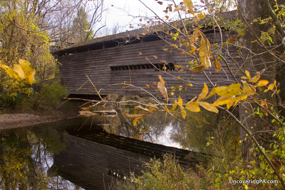
Sheeder-Hall Covered Bridge

The entrance to Sheeder-Hall Covered Bridge.
Also known as Hall’s Covered Bridge, Sheeder-Hall Covered Bridge crosses either French Creek or Birch Run, depending on which website you go with. However, the creek is the same as French Creek on the map, so I’m not sure if it changes names (though the exact name of the waterway is probably not super important).
The bridge is the oldest of the 15 still-standing covered bridges in Chester County and was built in 1850. The bridge is 100-feet long and crosses the creek in two spans.
This is almost certainly the least trafficked of the five bridges covered in this article as it’s the most remote. Getting a good view of the bridge can be a bit challenging because it is posted as private property on all four sides. However, the signs do seem to indicate that fishing in the creek is okay as the word “fishing” has been blacked out on the no trespassing signs and there are several signs about the creek being stocked with fish scattered around the bridge.

Another view of Sheeder-Hall Covered Bridge.
So, while I would imagine a few people looking at the bridge wouldn’t be a problem, I would definitely consider venturing past the signs as “proceed at your own risk.”
Getting There: Sheeder-Hall Covered Bridge is located in a rather rural area and spans the border between East Vincent Township and West Vincent Township. On the west side of the bridge, there is a small area big enough for one small car. However, on the east side of the bridge, there are ample places to pull off alongside French Creek Road. This is your best option for parking in my opinion.
Larkin Covered Bridge

The beautiful, but difficult to reach, Larkin Covered Bridge.
While Sheeder-Hall is the most rural of the bridges in this article, Larkin is definitely the least. Located along the very busy Graphite Mine Road in Downingtown in Chester County, the bridge is easy to see, but difficult to access.
The bridge was originally built in 1881 and spanned 60 feet over the nearby March Creek. However, it was moved when March Creek Dam was created in the 1970s. It was again moved in 2006 to a fitness trail adjacent to the road and a large neighborhood. In the amusing words of Wikipedia, “It currently spans nothing.”
The bridge itself is quite beautiful, but its current location certainly detracts from the overall beauty of the bridge.
Getting There: If all you want is a quick peek at the bridge, a drive along Graphite Mine Road will suffice. However, if you want to get a better look at the bridge, you’ll need to park a decent distance from the bridge and walk the paved path.
When school is out, you might be able to park at the nearby Pickering Valley Elementary School. Conversely, Saint Elizabeth Catholic Church may also offer some parking when not holding services, but neither location is ideal as they both require a bit of a walk to get to the bridge. Unfortunately, there just isn’t a great place to park for visitors to the bridge.
Now that you’ve read about the five most northerly covered bridges in Chester County, check them out on the map below and then make plans to visit them.
I’ll be writing about the other 10 bridges in the county at a later date, but until then, check out PACoveredBridges.com for a bit of information about them and their location.


Be the First to Comment!