- HOME
- DAILY GPI
- SHALE DAILY
- NGI
- DATA
- *NEW* Forward Look Price "Snapshot"
- Daily Price "Snapshot"
- Weekly Price "Snapshot"
- Bidweek Price "Snapshot"
- Bidweek Alert Data
- Shale Gas Prices (subscriber-only)
- Price Data "Learn More"
- > NGI Price Methodology (pdf)
- > Publishing Calendar (pdf)
- > NGI Datafeed Spec and Automation
- > Price Table Change Notice - Jul 2014

 )
)

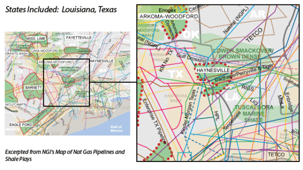
Haynesville Shale

Haynesville Overview:
The Haynesville Shale is a massive dry natural gas formation
in Northwest Louisiana and Eastern Texas that lies at true vertical depths
between 10000’-14000’.
Read More
Haynesville Counties:
TX: Gregg, Harrison, Nacogdoches, Panola, Rusk
Read More
Haynesville Pipelines (natural gas):
Acadia Gas Pipeline, Atmos, Carthage Hub, CenterPoint Energy, Enterprise Products, Gulf South, HPL, KM Tejas, Louisiana Intrastate Gas, Mississippi River Transmission, NGPL, RIGS, Southern Natural, Tennessee, Texas Eastern Transmission, Texas Gas Transmission, Tiger Pipeline
Read More
Haynesville Net Acreage Table:
A table detailing the net acreage owned by various companies in the Haynesville/Bossier shale.
View Table
ARTICLES