Friday, October 17, 2014

UPDATED: Oil-Laden Cargo Vessel Without Power & Drifting Toward Canadian Coastline

UPDATED OCT. 18, 2014 at 9:42 AM: Canadian Coast Guard patrol vessel Gordon Reid has gained control of the "Симушр" and is towing it out to sea. As of 6:00 am, the Reid had put 14 miles between the stricken tanker and the coast of Haida Gwaii. USCG Spar is arriving on the scene, but the American tugboat Barbara Foss was still over 200 miles out.


The situation looks more promising, but winds are picking up again and more inclement weather is anticipated. More from the CBC... 

ORIGINAL POST: Canadian media and the Council of the Haida Nation are reporting that a 443 foot Russian cargo vessel lost power early this morning in gale-force winds, and is now slowly drifting towards the Canadian coastline. The Симушр (pronounced "Simushir") is a cargo vessel, but is also laden with over 110,000 gallons of "bunker fuel" (a heavy fuel oil) and 13,000 gallons of diesel fuel (500 and 60 metric tonnes, respectively). 


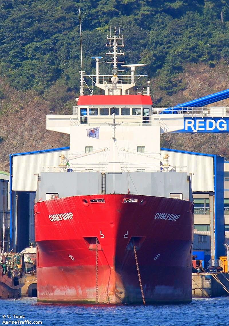
From MarineTraffic.com - The СИМУШР in port in Busan, S. Korea.

According to satellite AIS data, the vessel is 10 miles SE of the coast, and slowly drifting almost due north at an average speed of 2.87 knots (3.3 mph) over the last 9 hours. Weather reports referenced by the Haida Nation stated, "Thirty-five to forty-five [MPH?] south-east winds are blowing the vessel to shore in a 7-10 metre sea." However the release also stated that the winds are expected to turn westerly in the afternoon. 


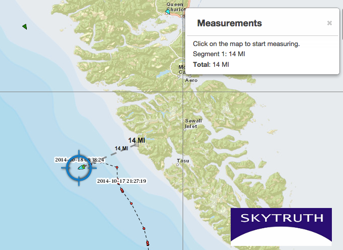
Timeline of the СИМУШР's drift since Oct. 16, 2014 based on satellite AIS data. The vessel is currently 10 miles from the nearest point of land.

A weather buoy off the coast of Haida Gwaii is reporting that the wave height is down to 4.5 meters, but the winds are still coming from the southwest at 16-19 knots (~18-22 MPH). We cannot say with any certainty how the currents or winds will effect the vessel as it gets closer to shore, but a few straight-line calculations may put the risk in perspective.


If we plot a straight line from where the Симушр reported it was no longer under command, through the vessel's last reported location, all the way to landfall with the coast; we find it has drifted approximately 29 miles in just under 9 hours. On this trajectory, it could reach the northern part of Haida Gwaii in 26 miles during the early hours of October 18th.

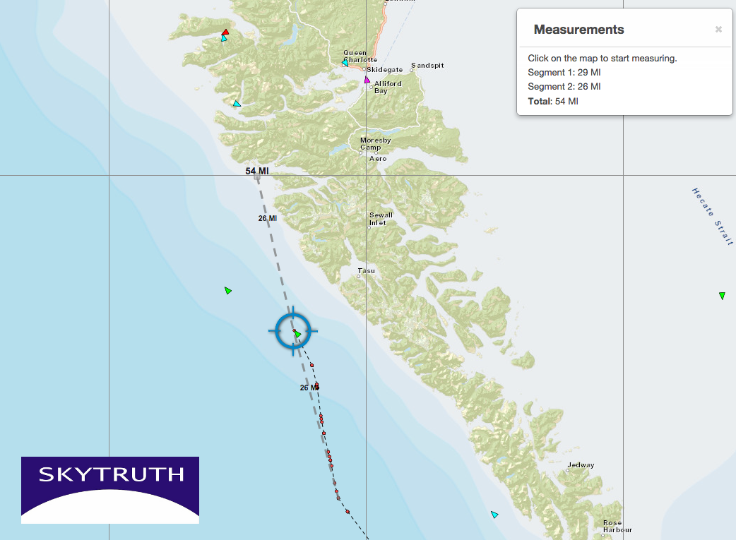
Fortunately, the last few reports show the path is shifting slightly toward the west. If we plot a straight line between the last two reported locations...


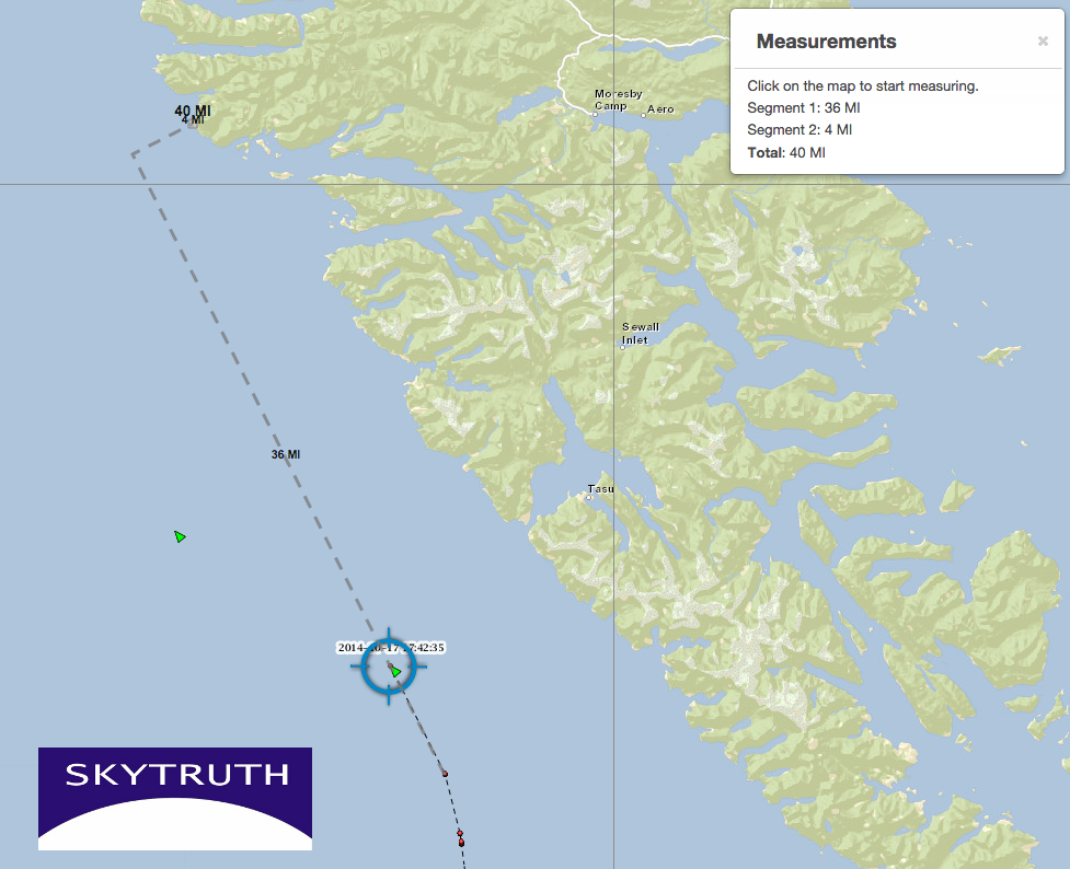
This trajectory clears the coastline by 4 miles, again in the early hours of tomorrow morning. 

However, ocean currents and winds do not follow straight lines, so reality will almost certainly be somewhat different than these projections. Thankfully, nearby vessels like the North Star, an 839 foot American container ship, are closing in on the stricken ship to assist it. Additionally, the Gordon Reid, a Coast Guard Patrol Vessel, is only 21 miles away and closing fast. The Reid was originally reported to be 750 km (466 mi) away. This post will be updated as details unfold.


###

Friday, October 10, 2014

'Cartographies of Energy and the Environment" at NACIS 2014

Yesterday, SkyTruth Communications Director David Manthos was in Pittsburgh, Pennsylvania talking about "Cartographies of Energy and the Environment" at the Annual Meeting of the North American Cartographic Information Society (NACIS).
This year's conference theme is Cartography and Time, offering a perfect opportunity to cover some of the ways we try to display the passage of time in our maps and images. They include this handy tool to let you compare a change over-time (like how much land the Gulf Coast has lost since 1972) just by sliding your mouse back and forth.


Read below the break for the slides and more visualization examples...


Friday, October 3, 2014

SkyTruth Releases Map of Drilling-Related Impoundments across PA

Thanks to the efforts of several hundred citizen-scientists who participated in our FrackFinder PA projects, we are releasing a map of fluid impoundments that we believe to be associated with drilling and hydraulic fracturing (fracking) in Pennsylvania's Marcellus Shale. 

Among other public and environmental health concerns, the shale drilling boom in Pennsylvania has led to construction of hundreds of large ponds and reservoirs to hold the water needed to frack modern shale gas wells, and to contain the "flowback" or "produced water" that returns to the surface laden with toxic and often undisclosed chemicals


Click here or above to explore a full-screen, interactive map: This map displays impoundments related to shale gas drilling and hydraulic fracturing (fracking) in Pennsylvania, as identified by SkyTruth staff and volunteers on USDA aerial survey photography from 2005, 2008, 2010 and 2013. The backdrop for this map is the most recent statewide imagery from 2013, but note that older ponds identified on the 2005, 2008, or 2010 imagery may have been reclaimed by 2013.

Did we miss an impoundment, or mark a pond that isn't really related to drilling and fracking? Let us know - info@skytruth.org- and please include as much detail as possible (pictures, GPS coordinates, etc).


These impoundments are of interest to researchers at Johns Hopkins University who are investigating the public health implications of living near drilling and hydraulic fracturing. We couldn't find any existing public map or dataset that would do the job, so we put together the FrackFinder program and asked for your help. 

We already knew that living next to one of these massive impoundments could be a headache (figuratively, if not literally too) because we noticed last year there were ten separate complaints to the National Response Center from five different residential addresses surrounding the 13.5 million gallon Carter Impoundment in Washington County. Since then, our partners at Earthworks published a detailed case study of this site, and Range Resources was recently fined $4.15 million by Pennsylvania's Dept. of Environmental Protection (DEP) for violations at the Carter Impoundment and five other centralized fluid impoundments in Washington County. The penalty is the largest fine to date assessed against a shale gas driller by PADEP.   


Preliminary Findings:


Year     Number of Ponds      Area – Average (meters2)      Area – Median (meters2)
2005
11
608.9
344.9
2008
237
1,040.9
558.8
2010
581
3,416.9
2,001.6
2013
529
7,552.8
6,209.7

In 2005, drilling was just getting started so we don't see many ponds or very large ones. But as drilling ramped up, the ponds grew progressively larger. From 2010 to 2013 the median area of drilling impoundments more than tripled, and the average area (which also includes small fluid reserve pits located right on the wellpad) more than doubled. As of 2013, the total impoundment surface area measures nearly four million square meters, scattered across the Commonwealth. (New York's Central Park measures 3.4 million square meters.)

We also observed that these impoundments are not permanent and may be reclaimed after a few years. Of the 581 ponds we delineated in 2010, only 116 of them were identified again on 2013 imagery.

Keep reading after the break to learn more about how we produced this map. 
*****

Sunday, September 14, 2014

Sanctions on Russia to Freeze ExxonMobil's Arctic Drilling Efforts

Last week the U.S. Treasury Dept. issued new sanctions that are expected to force ExxonMobil to halt its current Arctic drilling operations, a $700 million dollar partnership with Russian energy company Rosneft. Earlier sanctions only applied to new financial transactions and therefore did not stop the energy giants from moving the West Alpha drilling rig hundreds of miles north of the Arctic Circle to begin drilling for oil in the Kara Sea. On August 9, Vladimir Putin gave the go-ahead to start drilling in the Universitetskaya (Университетская) Prospect, making this venture the northernmost oil well in Russia. However, ExxonMobil now has just until the end of the month to wrap up their operations.

ExxonMobil and Rosneft planned to complete the project during the brief ice-free season between August and October. In early July, barely a month before the West Alpha rig arrived from Norway, the Kara Sea was still covered in ice (above). 

As we've written before, there are a number of reasons to be concerned about drilling in the Arctic. We've seen the devastation caused by a blowout in the relatively calm waters of the Gulf of Mexico, and this drilling operation is 385 miles northeast of Gazprom's controversial Prirazlomnaya platform that Greenpeace activists boarded last year.

What is so worrying about drilling in the Arctic? Aside from the unforgiving weather that can tear a 28,000 ton drill rig from its support vessels and drive it ashore, there are no technologies proven to clean up spilled oil from the ice that covers the region most of the year. And this ice is always moving: consider what the Kara Sea looked like in July (above) compared to August (below). At 68² km, the 11 km long chunk of ice identified above is larger than Manhattan.  According to Rosneft, the West Alpha rig is outfitted with sensors to track advancing sea ice, and they claim to be able to shut-in the well and move the rig if necessary.


(Above) As of August 22 the ice had retreated. 

Clouds often block the view of electro-optical satellites like Landsat, but synthetic aperture radar on satellites like the European Space Agency's Sentinel 1-A can peer through clouds and collect data on vessel locations, oil slicks, and sea ice, day or night. While we wait for Sentinel to begin routine data collection, we are watching vessel activity around the West Alpha rig using satellite AIS tracking data. (To read more about our work with satellite AIS, click here)

(Above): AIS data show the path taken by the West Alpha rig as it was towed from Norway to its current location in the Kara Sea.

(Above): With our AIS data viewer we can "see" all of the broadcasting vessels operating around the West Alpha. This may also allow us to see if vessels appear to engage in oil-spill clean up operations. 


Looking at Landsat's 15-meter panchromatic band (Band 8), we can just make out the rig and several support vessels. We've been able to definitely identify the two vessels east of the rig. The furthest vessel to the east is the REM Supporter and the vessel in the middle is the Loke Viking. The identity of the vessel right beside the rig is unknown. 

It is worth noting that the West Alpha rig has not broadcast its location since August 14. It is not to clear to us from the IMO regulations if they are required to continually broadcast their location until they are safely back in port, but it is not uncommon for drill rigs to stop broadcasting when they are "on-station" and not moving.

According to Rosneft, drilling began in early August and was expected to take two months. But under these new sanctions Exxon has to wind down their activity and secure the well by the end of September. 

Thursday, September 11, 2014

Disappearing Mississippi Delta, 1972 - 2014


Like many folks, we were astonished by the recent ProPublica / The Lens mapping work showing the tremendous loss of marshland in the Mississippi Delta and adjacent parts of the Gulf coast.  There is an unholy alliance of factors responsible:  the rise in sea level due to melting onshore glaciers and icepack, and thermal expansion of the ocean, two consequences of global warming; the natural, inexorable subsidence of the Delta as that huge pile of sediment compresses and sinks under it's own awesome weight, actually depressing the Earth's crust; the diversion of Mississippi River sediments away from the marshes and out into the Gulf, thanks to an impressive system of dams, levees, and pumps designed to control flooding and aid navigation; and the accelerated erosion of marshlands thanks to the criss-crossing network of ditches and canals dug willy-nilly by the oil and gas industry over many decades -- the death by 1,000 cuts.  

This last factor has prompted some of Louisiana's coastal parishes to sue the oil and gas industry, a "bite the hand that feeds you" course of action that might have been unthinkable just a few years ago.  But desperate times breed desperate measures.  There is an ambitious $50 billion plan to "fix" the Delta.  The billions of dollars in Clean Water Act fines that BP and their partners will pay for the 2010 BP / Deepwater Horizon oil and gas disaster could provide a solid downpayment on this recovery plan.

Here's our own look at the severity of the problem.  Thanks to the colossal archive of Landsat satellite imagery available for free via the US Geological Survey, we can time-travel back to the early 1970s to get a big-picture perspective on how much has changed.  Click on the images to see a larger version:  

1972: Mississippi Delta and Louisiana coastline as seen on August 7, 1972, just 15 days after the launch of the first Landsat Earth-imaging satellite.
2014: This mosaic of two images collected by the Landsat-8 satellite in 2014 starkly illustrates the loss of marsh vegetation (green)  over the past four decades.

Friday, September 5, 2014

A Higher-Resolution Look at United Kalavrvta

At the suggestion of Rob Simmon from NASA, we've produced a view of the United Kalavrvta from August 4, 2014, using the high-resolution panchromatic band (Band 8) of the Landsat-8 image.  Much sharper, as expected.  And now we measure the vessel length on the image at 282 meters -- very close to the 275-meter length reported by Fleetmon for this supertanker. 

Compare with the lower-resolution multispectral composite from yesterday's blog post:

Detail from Landsat-8 image taken August 4, 2014. Panchromatic band (15 meter pixels).  United Kalavrvta marked by red circle.  A similar-sized vessel also appears to be anchored about 4km to the west.  Compare with multispectral image below. 
Matching detail from multispectral (visible band) composite with 30 meter pixels.

Wednesday, September 3, 2014

Playing Hide-and-Seek! With an Oil Tanker.

Supertankers loaded with crude have been making the news recently, mostly because they can't find a place to sell the stuff. These tankers departed from Kurdistan, but Iraq claims the oil they carry is their property and the Kurds don't have the right to sell it.  This global political dispute is playing out on the water in an interesting, albeit risky, way: the tankers are unable to come into port, so are lingering offshore, fully loaded, waiting for some kind of resolution.

Late in July, we tracked the tanker United Leadership as it roamed across the Mediterranean and loitered in the Atlantic off the coast of Morocco.

Now we're following one that's a little closer to home:  the United Kalavrvta has been parked in a holding pattern in the northern Gulf of Mexico about 50 nautical miles southeast of Galveston. A few days ago Reuters noted that the tanker had "disappeared" from satellite tracking data, speculating they may be trying to offload their 42-million-gallon cargo of crude onto another vessel.  The US Coast Guard weighed in with this comment: 
A Coast Guard official said the vessel in the Gulf of Mexico might have turned off its beacon, sailed beyond antennas that monitor transponders, or perhaps some antennas might have been taken out of service.
Um, that's not quite right: tankers are required by international maritime law, AND by US Coast Guard regulations, to continually broadcast their position, heading, speed and other information using a Class A AIS system when they are between ports. There should be no threat of piracy in the US Gulf of Mexico, so the captain has no legal justification for turning the system off, until the vessel is safely in port.  Which it is not.  And the AIS signals sent by the relatively powerful Class A transmitters on tankers and other large cargo vessels are readily picked up by AIS satellites, which can cover the entire ocean.  If the captain turned off his AIS, perhaps the US Coast Guard needs to go pay him a visit and enforce US law.  

So where is the United Kalavrvta?  Right where it's been for weeks, since it showed up on July 27.  See below for the details: our vessel-tracking expert Bjorn prepared this series of maps and info yesterday, using our satellite AIS data feed from exactEarth.  We hope the Coast Guard can make use of this to resolve the inconsistencies in broadcasting by this loaded supertanker.  After all, it's hurricane season in the Gulf, and a fully loaded tanker that is not broadcasting its location to all the vessels in the vicinity is a hazard to navigation, and a potentially colossal environmental disaster waiting to happen.  
--
Latest Position at: 2014-09-02 19:23:57 UTC
Latitude: 28.585117 Longitude: -94.249783
Course: 252.0°

Speed: 0.0kn
The United Kalavrvta is at anchor in the same location off Galveston. They resumed AIS broadcast but with some unusually long gaps between positions. Their last position was about 32 hours ago. Between the 26th and the 28th there was a 47 hour gap, between the 28th and the 30th there was a 53 hour gap. 

AIS data track showing path of United Kalavrvta over the past 90 days.
AIS data from September 2 showing position of United Kalavrvta at anchor about 60 miles southeast of Galveston.
Zoomed-in detail showing AIS data for United Kalavrvta since August 24; the tight circular path indicates it's anchored (probably by the bow) and drifting around the anchor point as it gets pushed by wind and current.


Just for grins, we thought we'd see if this vessel shows up on Landsat-8 satellite imagery.  The most recent cloud-free image of this area was taken on August 4.  Sure enough, the faint pattern of a large oceangoing vessel appears exactly where the AIS data say the tanker was located on that day.  

It's tough to hide a supertanker:

Part of a Landsat-8 satellite image taken on August 4, showing a vessel in the reported AIS position for the United Kalavrvta.
Detail from Landsat-8 image showing a large vessel (pale elongated blob) at the AIS position reported by the United Kalarvrvta on August 4, 2014. Vessel appears to be roughly 240 meters long. FleetMon data indicate United Kalarvrvta is 275 meters long.  This is within the error of Landsat-8 imagery, which has 30-meter pixels.  Note another, similar-size vessel at center left.